Playmobil
By Robert Ellison. Updated on Saturday, June 7, 2025.

I recently got back from a trip back to the UK. Every time I go back these days something about the country has fundamentally changed. This time it's that every petrol station and motorway services has a Marks & Spencer or Waitrose supermarket embedded in it. On the motorway there are generally several large branches, and then a smaller branch in the toilet hand-washing area, and finally a tiny shop selling sandwiches and a small selection of ready-made curries in each cubicle.
At first pass this seems very convenient, but you can't fill up the tank in the smallest BP (paying at the pump being virtually unheard of in the UK) without getting stuck behind someone doing their weekly shop.
(Published to the Fediverse as: Petrol & Marks & Spencer #etc #uk #motorwayservices #petrol #waitrose #marks&spencer On this insane number of ever smaller Marks & Spencer outlets that are now everywhere in the UK. )
No book reviews this month.
#boarding SFO http://t.co/YLDFpmwF
Penn Jillette's rant against Obama's drug policy http://t.co/Ri5HAqxH
Congratulations @SpaceX -- Dragon arrives at space station in historic 1st http://t.co/91suk4ZV via @sfgate
Why your camera's GPS won't work in China (maybe) http://t.co/FQIFN8wI
Sigh, obvious, invalid, bullshit -- BBC News - Microsoft wins patent fight with Google's Motorola unit http://t.co/0PENWTCV
BBC News the secret links between Star Wars and Wales http://t.co/T8yEulCu (is there any tenuous link with Wales you won't publish?)
:) Hot weather to continue next week http://t.co/izAc2yA1
Not Skip's Tavern any more... http://t.co/dPx1NIj8
Reality rocks in San Francisco earthquake exhibit http://t.co/yo82B38b (Looking forward to this!)
BBC News - In pictures: Annular eclipse http://t.co/YA5F6or2 (Check out the Lemurs checking out the eclipse)
ITHCWY: Annular Eclipse at SFO: The only solar observatory outside the international terminal at SFO (some… http://t.co/ZqMXm8Ec
Beer was near, sadly earlier. http://t.co/2BeMAJZj
America's great divergence - American History - http://t.co/zQcVJIcQ http://t.co/fSdtXSvl
"Why won't you answer me?" - Parenting - http://t.co/zQcVJIcQ http://t.co/Ljzg6vpG (I should stop telling Kate about her 'milk head')
1906 earthquake refugee cottage at The Presidio. http://t.co/pof5LotA
+1 Judge suspends US law that provided for indefinite detention without trial - Boing Boing http://t.co/xsBuLyYb via @BoingBoing
Daniel Raven-Ellison, Guerrilla Geographer Information, Facts, News, Photos -- National Geographic http://t.co/DjgJdvMJ via @NatGeo
ITHCWY: Gopher Snake: Bernal Heights Park http://t.co/OoHYDU0y
Turned out nice... http://t.co/G2pHtgbd
RT @CatfoodSoftware: Blog: Catfood Software on Google+ and a Hangout Pledge: Catfood is now on Google+. Once 50… http://t.co/ZC84h8AN
ITHCWY: Open Immigration: I'm increasingly in favor of opening up immigration. Partly it's a general sense that a… http://t.co/cBLQT2rI
ITHCWY: Snake rests on Toad: At the California Academy of Sciences. http://t.co/YTQh682A
New Golden Gate Visitor center - lots of tat, no food :( http://t.co/vXmZn099
Obama sighting on morning dog walk. #fb http://t.co/wZdwN2Mj
President Obama: 'I Think Same-Sex Couples Should Be Able to Get Married'; http://t.co/CtC6k2A8 (shameful that it has taken this long)
Gaia revisited: http://t.co/sHSeFph7 - I'm still in the extreme camp: http://t.co/6dzIjBy7
Post Doyle Drive detour quite pleasant on the way home tonight. http://t.co/fSK8e4v9
THINKWALKS: http://t.co/ToOZo3KQ #todo in San Francisco @myEN
ITHCWY: Bottled Water: A company called Evive launched this week to battle the evil of bottled water with reusable… http://t.co/5X9e3emO
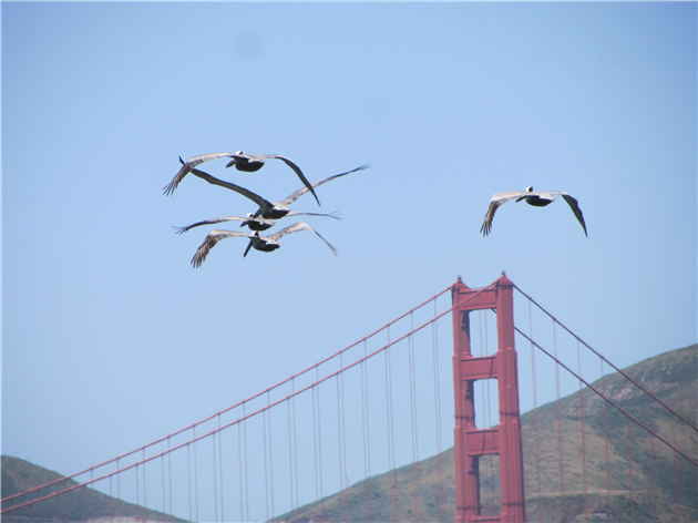
ITHCWY: Pelicans http://t.co/0xoup7z5
It's @KQED pledge yet again. Throw them a bone public radio freeloaders: http://t.co/00UvTamT
Illegal dumping can now be voted to fix at http://t.co/SsliF12n #bernal-heights!
Yet Another Awful Dumping Incident on Bernal Hill http://t.co/35kLDRdn via @bernalwood
+1 AllClear ID Rolls Out First-Ever Social Security Number Blocking Service For Children's IDs http://t.co/wnRILNzQ via @techcrunch
Rejected and controversial New Yorker cover art (the mentos one is very good) http://t.co/afo9AxZd via @BoingBoing #fb
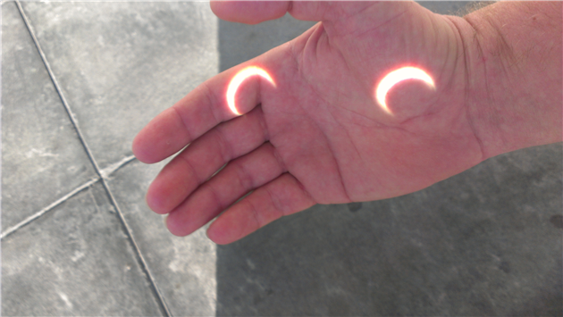
The only solar observatory outside the international terminal at SFO (some binoculars and a complicated harness of cardboard cup wrappers). Gathered quite a crowd!
(Published to the Fediverse as: Annular Eclipse at SFO #photo #eclipse Photo of the 2012 annular (partial) solar eclipse from San Francisco, California (at SFO) )
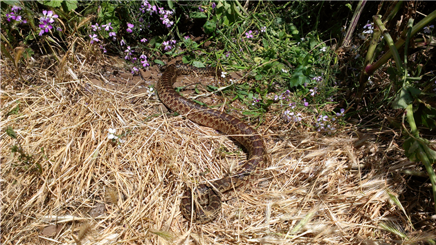
A Gopher Snake in Bernal Heights Park. They look a little like a rattlesnake but are docile and harmless.
(Published to the Fediverse as: Gopher Snake #photo #snake Photo of a Gopher Snake In Bernal Heights Park, San Francisco, California. )
I'm increasingly in favor of opening up immigration. Partly it's a general sense that a person shouldn't be tied to a country by the accident of birth. Being free to migrate seems to me like it should be a basic human right.
Partly it's the economic benefit. I'm in the software/Internet industry and I've been lucky enough to work in Silicon Valley via visa, green card and eventually citizenship. I hope I've also been a net benefit to my adopted home. I've certainly paid plenty of tax and helped to create a fair number of jobs. Vijay Govindarajan writing on the same topic lists a few more[1] illustrious transplants:
"Consider that the co-founder of Google is Sergey Brin, a Russian. The co-founder of Sun Microsystems is Vinod Khosla, an Indian. eBay was founded by Pierre Omidyar, who is French. The co-founder of Juniper Networks is an Indian, Pradeep Sindhu. YouTube was co-founded by Steve Chen, who is Chinese. Yahoo! was co-founded by Jerry Yang, a Chinese immigrant. Andy Grove, a Hungarian, co-founded Intel."
Not that you need to create a billion plus dollar company to have a positive impact.
There are of course economic risks - primarily cheap labor lowering wages (albeit also lowering prices) and freeloaders benefiting from social programs without contributing back.
But cheap labor is getting those jobs anyway. It's a fundamental inequality that companies can shop around internationally for cheap employees but people can't shop around internationally for a job. And the impact of the freeloader problem can be reduced by requiring some length of residency before providing benefits.
Of course some jobs require physical proximity and can't be outsourced and some level of freeloading will always be possible. This brings me to the third reason I support open immigration. It would bring a huge amount of focus to international development. If people are free to live and work where they want then there will be a huge motivation to improve living conditions and economic opportunity around the world. It might be the only way to make real progress in this area.
This policy could be unilateral, or it could be based on reciprocal treaty - the latter probably being more[2] practical, and hopefully fostering immigration in both directions.
[1] More in the sense of greater, not additional.
[2] More in the sense of closer to, I don't think it's actually very likely to happen.
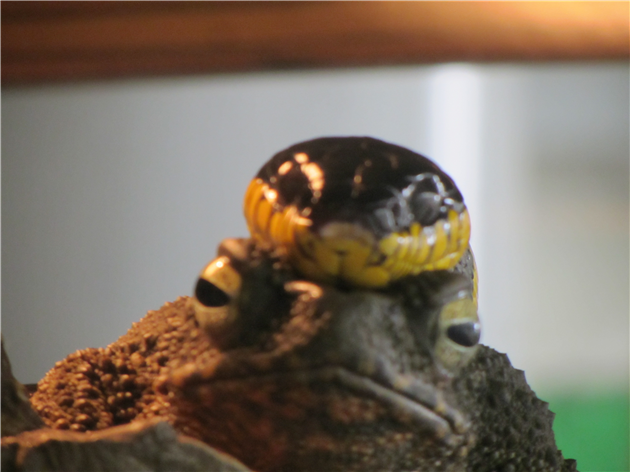
Photo of a snake taking a rest on a toad at the California Academy of Sciences.
(Published to the Fediverse as: Snake rests on Toad #photo #snake #toad A snake takes a break by resting on a toad at the California Academy of Sciences in San Francisco, California (photo). )

A company called Evive launched this week to battle the evil of bottled water with reusable RFID equipped bottles that need a special filling station that plays advertising to you while you refill. Sort of like a water fountain but worse in every way possible.
Concord Massachusetts just started to ban the sale of bottled water, joining several other towns and cities around the world. They've actually just banned small bottles, you can still buy a large one.
Wouldn't it be better to leave the water on the shelf and ban Coke?
Photo credit: Joost J. Bakker IJmuiden cc
(Published to the Fediverse as: Bottled Water #etc #water #evive #concord If you ban bottled water I'll just buy a coke, which by the way is in a bottle. )
3/5
Works as a good checklist of the various business, legal, technical, marketing and strategic considerations you should think of when launching an API. Not a huge amount of depth in any one area though.
4/5
A tale of legal and illegal drugs in San Francisco from the perspective of Sarah, a transplant from the mid-west in town to make money to send back to her sick father and expose the evils of the pharmaceutical industry. Reads like Sarah sat down next to you in a cafe and poured out her entire life story before you even knew what hit you.
Interesting, but the first book I tried was wrong: http://t.co/gUPyhpjM (The Interpreter in Look to Windward)
ITHCWY: Go-arounds: LEGO and Legislative Service: LEGO: I wrote in January about LEGO's[1] misogynistic latest LEGO… http://t.co/s2PlMzGn
ITHCWY: Kindle: Figure out sorting!: I love my Kindle. Loved it since seeing the screen for the first time after… http://t.co/zimbDLpz
ITHCWY: Catfood: Cleat 1.10: I've just released an updated version of Cleat that supports geolocation and… http://t.co/SESV9VH7
4 of 5 stars to Pharmacology by Christopher Herz http://t.co/SgGZR4Lz
I still don't like the Oxford Comma, but... http://t.co/oJB50wGw
ITHCWY: Prophylactic: Absolutely no chance of scurvy tonight. http://t.co/RpX1z78M
Artist Captures Dog vs. Gopher Confrontation on Bernal Hill http://t.co/OlUgGHOG - It could be Rudy...
Graffiti - Public - Other_enter_additional_details_below/101 Elsie St San Francisco, CA 94110, USA http://t.co/c9P7xkjx #bernal-heights!
Lego tries to get less sexist http://t.co/WD9lmRuK - and previously: http://t.co/Psc5ZNua
"It’s the product development version of the Hunger Games" - http://t.co/wNA0DHWy via @uservoice
SciFi in HiFi! - Sean Young's video of the making of Dune - Boing Boing http://t.co/BXTACFpj via @BoingBoing
Shocking, but need to distinguish between standardized tests and shit standardized tests: Florida standardized... http://t.co/c8488XDw
+1: Introducing the Innovator's Patent Agreement http://t.co/naK9hYxw via @twitter
Extraordinary: The real criminals in the Tarek Mehanna case http://t.co/GOqxgIJ2
They are deadly serious about not taking photos at @#spamalotsf http://t.co/5di7viuy
JSON Formatter & Validator: http://t.co/L220TCHf
ITHCWY: California Slender Salamander http://t.co/EvNlFOnS
Patent Law 101: What’s Wrong And Ways To Make It Right http://t.co/6QnLLHL7 via @techcrunch
ITHCWY: Even Shitier - Citibank Remortgage Scam: Citibank contacted us in December offering to remortgage our house… http://t.co/mxGi3j6K
ITHCWY: Baby Yellow Spiders: A chair in our garden has produced a bumper crop of baby Cross Orbweaver spiders. Very… http://t.co/0VBjSvPq
Wow: http://t.co/N4tbm77Y Rear Window loop via @jwz
Final Plan for Bernal Hill Trail Restoration Unveiled: http://t.co/bp3uFOZu - from @bernalwood
RT @Pearldotcom: Our new site is coming soon! Get on the list to be notified about launch details: http://t.co/75ddUi63
ITHCWY: Sod Searle And Sod His Sodding Room: Marcus du Sautoy, writing on BBC News, brings up Searle's Chinese Room… http://t.co/FmcVPbzC
ITHCWY: California, I can save you billions with a small and reasonably priced computer program...: California just… http://t.co/Ro96lk3J
California, I can save you billions with a small and reasonably priced computer program... http://t.co/iDZEbAQ9 -> @JerryBrownGov