Hudson Yards

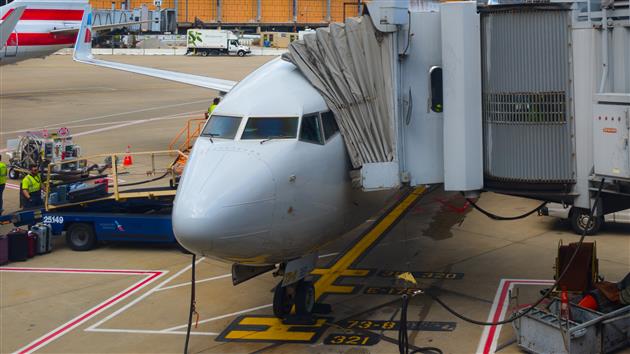
West Side Storage Yard at Hudson Yards in New York

Google Pixel 8 Pro 2mm f2.0 1/3,817s ISO43

Photo of the Long Island Railroad storage facility in front of Hudson Yards in New York City (one end of the High Line park).

Add your comment...

Related Posts

(Recent Photos)

(Published to the Fediverse as: Hudson Yards #photo #newyork #hudsonyards #lirr #highline View of LIRR storage and Hudson Yards from the north end of the High Line in New York )

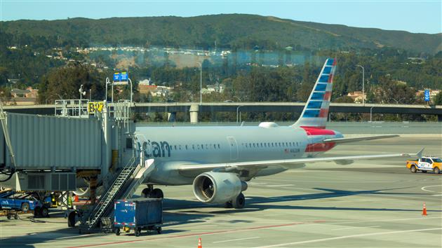
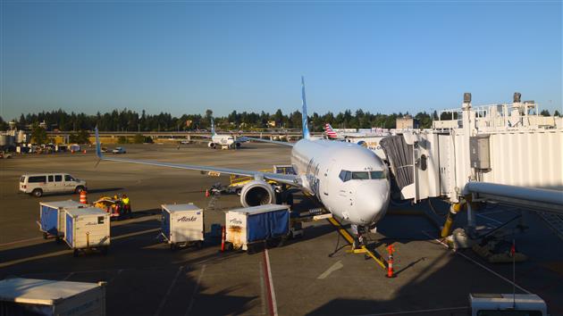
SFO EWR

SFO EWR

Google Pixel 8 Pro 7mm f1.7 1/25s ISO667

AS384

Add your comment...

Related Posts

(Recent Photos)

(Published to the Fediverse as: SFO EWR #photo #flight #sfo #ewr SFO EWR )

ITHCWY Newsletter for August 2024

Generated image of some random politicians with good hair.

Google has been sending me increasingly threatening emails about upgrading my Android apps and so August has been all about that. Helpfully Microsoft has also deprecated Xamarin (a tool I used to write software for Android) and so I also had to do a crash course in MAUI. Thank goodness for ChatGPT and GitHub Copilot. I also took this opportunity to figure out adaptive icons and generally update the look and feel of the apps.

Catfood Earth for Android has a new volcanoes layer and support for showing where you are on the satellite image.

Fortune Cookies for Android just works again, but that's not nothing.

I also made this timelapse of Fogust - San Francisco enveloped in fog - and this new to me hike in Pacifica has a nice hyperlapse (and some fog).

Previously:

Add your comment...

Related Posts

(All Etc Posts)

Catfood Earth for Android 4.40

By Robert Ellison. Updated on Sunday, September 29, 2024.

Catfood Earth for Android 4.40

Catfood Earth for Android 4.40 is now available on Google Play.

Earth has an updated look and feel and two new features.

The volcanoes layer has been ported over from the Windows version of Catfood Earth. When enabled this will show volcanoes that have recent activity (within the past week) using data from the Smithsonian Institution's Global Volcanism Program.

It's now possible to show your current location on the map. I'm not sure it's a replacement for Google Maps just yet but it does help you find where you are on the satellite image.

The release was prompted by Google requiring API level 34 support... completing this for Fortune Cookies was a nightmare but having learnt from that experience Earth made the jump to MAUI pretty smoothly.

If you already use Earth for Android you should get the new version shortly. If not, this is what Android live wallpaper was made for so give it a try!

Add your comment...

Related Posts

(All Code Posts)

Fortune Cookies for Android 1.50

Fortune Cookie Icon

Fortune Cookies for Android 1.50 is now available in the Google Play Store.

This update was driven by Google insisting that I target API level 34. Which is fair enough and I figured this would be a five minute task followed by a smooth release. I should have known better.

Of course the starting point is updating Visual Studio, updating the Android SDK, learning that my emulator won't launch any more and eventually coaxing it back to life. That's a couple of hours. Why this doesn't just happen when I'm doing other things I don't know, but for dev tools this has to be a ceremony.

Once all of that was done I learned that Xamarin was officially deprecated in May. I'm going to have to figure out MAUI.

There is a helpful migration page with this gob smacking advice:

"Once your dependencies are resolved and your code and resource files are added to your .NET native project, you should build your project. Any errors will guide you towards next steps."

I think they hired Yoda:

"Errors, they are. Guide you, they will, towards your next steps. Warnings, hmm, check them out you must... eventually. But information issues? Merely whispers they are, nudging you towards shiny new platform features, yes! Listen, you might, if time you have."

Anyway... the actual mechanics of getting this working in MAUI were not that bad. It could be that I need to reinstall my system with extreme prejudice but the platform itself seems to be very unstable. I constantly got Visual Studio and cryptic compile errors that went away on rebuild or a restart. Starting the android emulator has completely frozen my system several times requiring a hard reboot. I don't think I've had that experience since the Clinton administration.

Once it was finally working the Google Play Developer console wanted my "private" key, which I gave it; and to have a conversation about my tax situation in Cuba, which I'm ignoring for now.

As well as a brand new API target Fortune has a nifty new color scheme, a floating action button with a little fortune cookie on it, and will ask you nicely for permission to send notifications.

Add your comment...

Related Posts

(All Code Posts)

(Published to the Fediverse as: Fortune Cookies for Android 1.50 #code #fortune #software #cookie #catfood #xamarin #maui Catfood Fortune for Android is based on the UNIX command of the same name and will display a random and possibly no longer socially acceptable fortune from a less civilized era. )

Fogust

Fog over Twin Peaks in San Francisco

San Francisco gets a lot of fog in the summer. This brief time lapse, shot from Mount Tamalpais and the Marin Headlands shows just how much.

Add your comment...

Related Posts

(More Timelapses)

(Published to the Fediverse as: Fogust #timelapse #video #fog #sanfrancisco #karlthefog #fogust Time Lapse of San Francisco Fog in August (Fogust) )

Milagra Ridge

Milagra Ridge in Pacifica

Starting from this parking area makes for a brisk walk up to Milagra Ridge and then a nice loop at the top before returning by the same trail. Milagra Ridge used to be a Nike missile site (SF-51), still has some WWII remains (Battery #244) and a reservoir. I thought it looked like a nice enough day to brave Pacifica but by the time I'd loaded the dog and driven down the fog had swept in. Still a pleasant 3 mile hike.

Hike starts at: 37.643146, -122.488815. View in Google Earth.

Add your comment...

Related Posts

(Hike Map)

(Published to the Fediverse as: Milagra Ridge #hike #video #pacifica #sfdogwalk #hikevid #map A 3 mile loop hike at Milagra Ridge (GGNRA) in Pacifica, California )

ITHCWY Newsletter for July 2024

Federation

I have wanted a decentralized social network for a long time. Maybe this Fediverse thing is starting to get legs. Bluesky and Mastodon can now talk to each other via Bridgy Fed. Threads can post to Mastodon. ITHCWY has been on ActivityPub for a year now and it's become a significant source of traffic and comments. If you are on Mastodon or a federated service you can follow me at @[email protected]. I plan to get even more federated over the next year.

I waded foolishly into the debate around turning the Great Highway in San Francisco into a park, and found that the data doesn't support the fear of carnage in the Sunset when this road is closed. I also made a custom GPT to discuss the San Francisco budget with, and had to spend some time writing the missing manual to even know what to ask. Too late now, but here's a guide to the March ballot measures (watch this space for November) On a national level I got to update my NPVIC page now that Maine has joined.

Some photos... I knew that black bears could be brown, this one is very brown. Some humpback whales. The first commercially available glow-in-the-dark plant.

Milky Way timelapse from Canada. Partial Solar Eclipse from Inverness (CA).

Tunnel Mountain is a great hike in Banff (start from anywhere in town). Bolinas Point Loop is better if you're closer to Bolinas (which I mostly am).

Previously:

Add your comment...

Related Posts

(All Etc Posts)

Tunnel Mountain

Tunnel Mountain, Banff

Elk on Tunnel Mountain in Banff

View along the Bow River in Banff

Hike from Banff to the Hoodoos on the Bow River, then around the back of Tunnel Mountain and back to Banff. Clearly you could close the loop but in this case we had some well deserved ice cream and then got the bus back.

Hike starts at: 51.18497, -115.554382. View in Google Earth.

Add your comment...

Related Posts

(Hike Map)

(Published to the Fediverse as: Tunnel Mountain #hike #banff #tunnelmountain #map Hike taking in the Bow River Hoodoos and Tunnel Mountain in Banff, Alberta, Canada. )

Brown Black Bear

Black Bear

SONY DSC-RX10M4 220mm f8.0 1/250s ISO1000

Photo of a black bear near Blue River, British Columbia. I knew that black bears are sometimes pretty brown - this is a very brown black bear.

Add your comment...

Related Posts

(Recent Photos)

(Published to the Fediverse as: Brown Black Bear #photo #bear Photo of a very brown black bear near Blue River, British Columbia. )