Links for February 2024
By Robert Ellison. Updated on
Trident missile test fails for second time in a row
We should be kicked off the security council until we can make this work. #uk #trident
Trident missile test fails for second time in a row
We should be kicked off the security council until we can make this work. #uk #trident
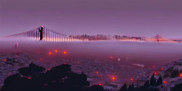
January has been nearly all timelapse at ITHCWY. First up I have my annual New Year's Eve production, this time a portrait of the Embarcadero in San Francisco. Apparently the Port Authority and US Army Corps of Engineers have a plan to lift this stretch of shoreline by 7 feet to protect it from climate change. I also got a chance to visit Miami, and produced a timelapse of the skyline and the world's latest largest cruise ship, the Icon of the Seas. It's so big it can spell it's own name out using windows as pixels. This is the ship causing the climate change that necessitates lifting the Embarcadero. Finally some present day construction, two months of light rail track replacement on my street.
Also, some reviews for January. I would in particular recommend Leave the World Behind.
Previously:
Happy New Year!
Catfood Earth 4.40 includes the latest time zone database and also some fixes for the locations, volcanoes and weather radar layers. If you use any of that please update.
I'm slowly replacing myself with an LLM. Currently I'm on Rob 2.1 which features a fine tuned version of GPT 3.5, retrieval augmented generation (RAG) and some prompt tuning. You can chat with it in the comments. Don't worry, it's not blogging yet, the aim is to start sending it to some meetings.
Just how different are nanoplastics and microplastics? More on free will. It is time we actually tried some tyranny of the majority for a bit.
An animation of PM2.5 pollution across the US in 2023.
Time lapse of the full Hunter's moon and Jupiter (and some Galilean moons).
Reviews for October, November, and December.
Previously:
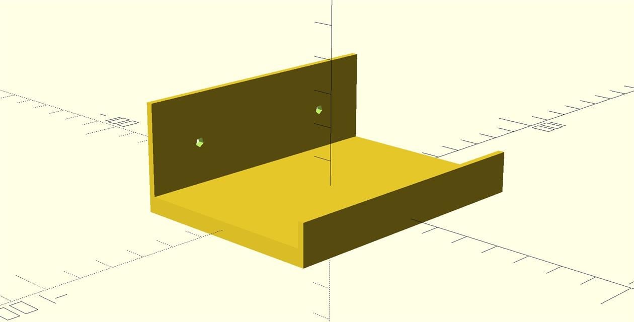
I got the Aura Carver Mat for Christmas. It's a nice 10 inch digital photo frame with great Google Photos integration - hook it up to an album, invite people to the album, add photos. You can also use the Aura app for sharing but a Google Photos album is way easier. I got this to replace an Echo show because I had started spending too much time switching off all the ads. Even after you've toggled off every bit of marketing fluff the thing still shows you ads. It's one thing if it was sold as ad supported but quite another to continually sneak them in via software updates. I like Alexa and so I replaced it with the Echo Studio (so much sound) and this frame which so far just works.
One minor detail is that this frame is designed to sit on a desk or shelf and does not contemplate living on a wall. I designed this discrete shelf for wall mounting. It's pretty small which is good, I'd recommend some double sided tape or similar to stop the frame from sliding sideways in case you're as bad at using a spirit level as me (or live in an earthquake zone, also like me).
OpenSCAD code below, or grab the STL from Thingiverse.
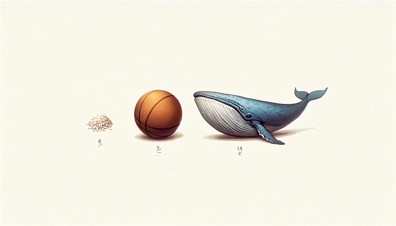
Vice has a horrifying article on nanoplastics. I'll have to worry about them later though because Mirjam Guesgen trots out this amazing comparison:
"Microplastics are on the scale of micrometers, while nanoplastics are mere nanometers. To get a sense of just how small that is, imagine the difference between the size of a WNBA basketball (which is slightly smaller than the NBA equivalent) and a grain of rice."
If we're getting a rough sense of the difference from rice and basketballs what on earth could be the motivation to make it a WNBA basketball? How slightly smaller is it?
"A standard NBA basketball has a diameter between 9.43 and 9.51 inches. In the WNBA, the basketball has a diameter of between 9.07 and 9.23 inches. Basketballs used in the NCAA are between 9.39 and 9.55 inches for men and 9.07 and 9.23 inches for women."
Around 5% smaller by diameter at most.
Also, is the WNBA / NBA distinction meaningful when we're not defining the type of rice? Basmati is 6-8 mm, so way more variability than basketballs. I don't even need to bust out the short grained varieties. This is so crazy I had to check out the plastics as well.
Guesgen says microplastics are on the scale of micrometers which is kind of what I had assumed too. But then I'm not a science journalist. Some light googling reveals that microplastics are fragments under 5mm. Some rice would be a microplastic, if it was plastic rice. I guess everything can be measured in micrometers but 5mm is 5000 micrometers. So what are nanoplastics? Maybe 5 micrometers and smaller?
"For particles smaller than 1 μm, they are defined as nanoplastics"
And:
"The term “nano” in nanoplastics tends to be contentious as many researchers follow the convention for nanoparticles that are defined as particles having a size approximately between 1 and 100nm."
Both from ScienceDirect.
So at the extremes that's five million times smaller, or to get a sense of just how much smaller imagine the difference between a grain of rice and around 1,300 blue whales, nose to tail. For the largest plausible nanoparticles, still about a whale. I'm not going to get into the gender.
The Washington Post: “Do I Know You?” examines what it's like to have face blindness - The Washington Post
I'm on the who the hell are you end of this spectrum. #prosopagnosia
--
Tom's Guide: By the way, did you know Alexa's annoying suggestions can be turned off? Here's how
Alexa, stop by the way apparently. Saving for future use. #alexa #shutup
--
Bridgy Fed
The docs suggest just passing a fragment will post part of a page but this doesn't seem to work, so testing again with a parameter as well... #ithcwy
--
San Francisco Examiner: How to download new Muni app on Apple App Store, Google Play | Transit
A new app and a new account... Is this just to escape the 2.8 rating? #muni #sfmta #sanfrancisco
The 'New' label from the New Microsoft Teams Taskbar Icon.
Go vote for this! I can't cope without a notification icon badge in Teams.

What is it about free will skeptics and their insistence that we completely reorganize society based on their realization that nobody controls their own actions in any way? The Munk Debates just published Be it resolved, humans have free will, and it's a classic of the genre.
There is an interesting nugget at the start, which is how much of what we decide is based on extraneous factors. I'd love to go deep on that debate. I thought I wouldn't have time to write about this podcast as I needed to mop some floors. But my wife decided to steam clean them instead and so this post wouldn't exist without events that are completely beyond my control. But it also wouldn't exist if I wasn't interested and didn't want to write it.
Unfortunately instead of that debate we get the discussion about how with no free will criminals have no choice about commiting crimes and therefore we should not punish them. The first part of that may very well be true, much more on that subject here. The second part though shows such catastrophic misunderstanding that maybe it acts as a kind of proof. Nobody with free will could fail so comprehensively to follow their own argument to its logical conclusion, and so free will cannot exist.
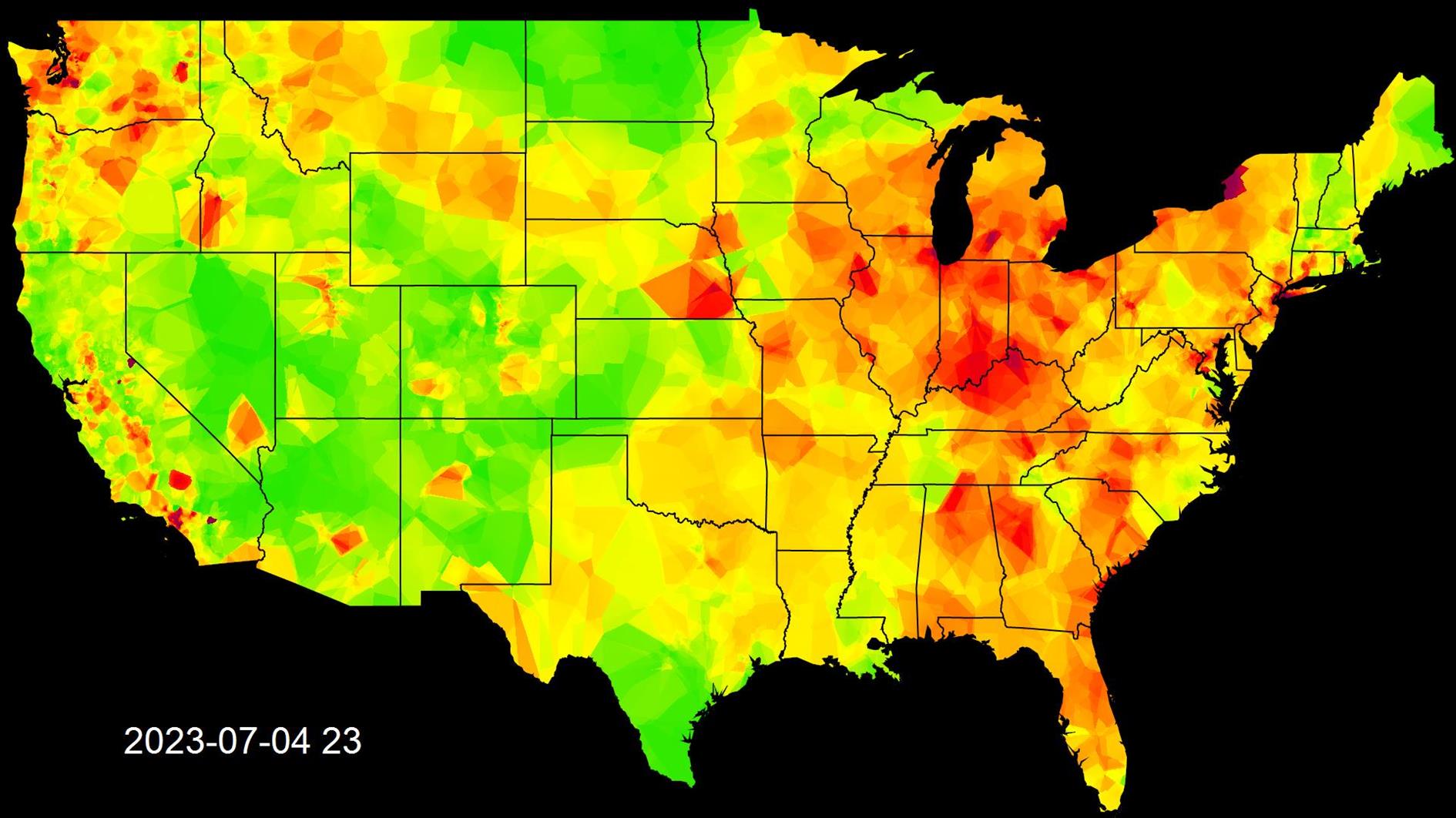
The video below shows PM2.5 air pollution in the United States from February to November 2023. The frame above is the impact of fireworks on the 4th of July. It's a blink and you miss it moment in the video but a pretty incredible impact.
I started this project in February expecting it to be more of a long term thing. Unfortunately, Purple Air started charging for their API in November, more than I was willing to pay for this project.
In terms of wildfires this year the big story in the continental US has been Canada belching plumes of smoke down across the East Coast. I didn't include Hawaii or Alaska in the map and so there is nothing for the tragic Lahaina fire on Maui.
To make the video I had a Google Apps Script running that pulled the Purple Air sensor data hourly. I then wrote an app to periodically render the data to frames using my shapefile library to plot the US and then interpolating the air quality for each pixel from the nearest sensors. The frames are stitched together at 60 frames per second using ffmpeg and final production was in DaVinci Resolve with music from Filmstro.
Catfood WebCamSaver 3.22 released with the latest web cam list. Catfood Earth for Android now supports random locations.
New tool - this page is updated every hour with a video of the last 48 hours of global IR cloud cover. Useful for tracking hurricanes and atmospheric rivers.
Sunset timelapse with a slider. And a video made from the highest resolution version of Blue Marble Next Generation.
Does the US need a third party? Also, sortition.
Some bubbles and a San Francisco Crayfish.
Reviews for August and September.
Previously: