News: Case made for 'ninth planet'
By Robert Ellison. Updated on
Case made for 'ninth planet'
Can we call it Pluto?
Case made for 'ninth planet'
Can we call it Pluto?

We'd probably be living in a post-scarcity Star Trek / Culture style universe happily working on self-actualization if we didn't have to spend so much time fucking around with OAuth.
When I run an app or launch a website it's generally because I've got some task to complete and a few free minutes to try and complete it.
Let's take Facebook for example. I want to quickly scan through to see which of my friends are sharing anodyne inspirational quotes superimposed over stock photography and silently judge them.
Facebook picks this moment to let me know about a new feature that will display previously unshared photos and videos to try and get me to share them. I'm instantly pissed off because of the unwelcome cognitive load and then I realize that the whole app has frozen. In fact every time I load Facebook at the moment it just hangs until I give up and do something else.
This is probably because one of my daughters has the endearing habit of shooting hour long 4K videos of the floor. The poor app is probably innocently trying to grab a couple of thumbnails and instead getting an object lesson in the halting problem. I'm sure this will eventually get fixed and it's not even the root cause of my current fury.
Got It
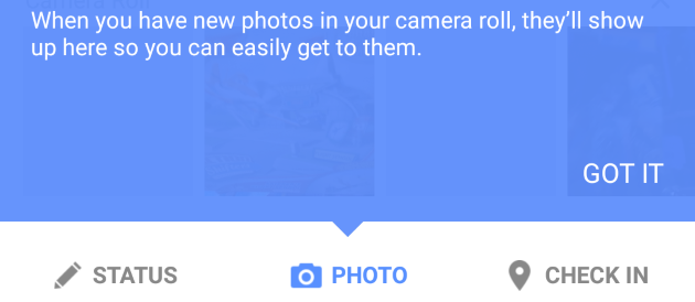
My only option is to click Got It. This chirpy little phrase is slowly infesting every corner of interaction design. It seems relatively innocuous at first but let's unpick it a little.
Generally Got It signals that something has been added to an app or site that the designer feels is important enough that they need to let me know about it.
This is almost always going to be bad news. Probably the way I complete my task has changed and I'm going to have to learn the new way. Maybe there has been a complete redesign and the use I had for the app was considered an edge case and has been removed. It could be that for legal reasons I need to be told that some new previously unpillaged corner of my privacy needs to be violated.
I'm immediately in a bad frame of mind when I see Got It.
Also there is rarely a Don't Got It or Don't Want It link. Got It is a sign that something is being forced on you and the happy language is an implicit forced value judgement that you've both fully comprehended the change and that you wholeheartedly agree with it.
It probably feels cute to designers that come up with this. After all, a whole team has probably toiled for weeks if not months to come up with a new way to cause my phone to hang. They really want me to use it. But you're not putting yourself in my shoes. I rarely care and usually you're making my day fractionally less enjoyable and the design should be about me and not you.
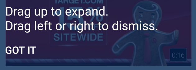
I miss OK. It's less loaded. I'm OK with dealing with whatever you're inflicting on me. It's not as good as OK / Cancel but sometimes OK is about the best you can expect.
I just don't Got It.
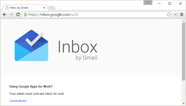
Google is generally pretty good about managing multiple accounts but sometimes you get completely stuck. One example is Google Inbox where your primary account is Google Apps for Work without Inbox enabled. You just get a screen saying that Inbox needs to be activated and no option to switch to another account.
There is a fix, and this sometimes works for other products as well. In the URL (https://inbox.google.com/u/0/) there is a user number. Change the 0 to 1 (or maybe 2, 3, etc depending on the number of accounts) and you can get Inbox up and running again.
One case I haven't found a clean workaround for is importing a segment or custom report in Google Analytics. You just get the default profile and if it's not what you're after then there is no way to switch. What does work here is launching an incognito window, signing in to the relevant account and then using the import link. A bit painful but gets the job done.
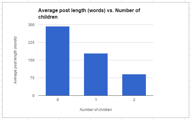
I have crunched the numbers and calculated the average length of blog posts on I Thought He Came With You vs. how many children I had at the time the post was written.

I started with Blogger many years ago. It worked well for a while and then it didn't. I forget why but I wrote a tool to migrate from Blogger to BlogEngine.net.
BlogEngine.net was good for a while, but I never loved the commenting system. I switched to Disqus and I wrote a tool for that as well.
Then Disqus decided to monetize more aggressively than I liked, and I moved on to Facebook comments. Having used these for a while I have come to the conclusion that most people just hate Facebook comments. They're convenient but not many people use them. Also, pages just load much faster without all the Facebook JavaScript. So today I'm switching to home grown manually moderated comments. Just about every comment ever left on this blog has made it from Blogger to BlogEngine.net to Disqus and finally the new system, even the nasty ones. I'll moderate to cut out spam but never dissent. Enjoy!
Microsoft you are literally killing me. Please tell me there is a reason.
Windows 10 has had a reorg of notifications. People in Redmond have spent quality time thinking about how and when to bother me. User experiences have been imagined, focus grouped, re-imagined, tested, pushed out to beta, revised, polished and finally shipped in a heaping turd of time wasting.
After one of the never ending reboots following some critical update or other I get a nice popup to let me know that updates were installed:
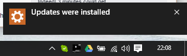
I'm not sure this is the most important news I'll read all day but fine, thank you and I click the little x to dismiss.
Windows at this point knows that it's told me about the updates, and it knows that I've seen the message because I took the time to actively dismiss it.
So why is this now in the Action Center:
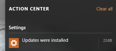
I have to acknowledge my latest helping of updates all over again. It's the sort of double confirmation I'd really value before inadvertently nuking Belgium but for pretty much anything I've ever seen in Action Center it's overkill. It's causing the most anger I've had with an Operating System since I had to Google how to shut down Windows 8.
Windows 10 is on 110 million devices. Assuming a reboot a week and three seconds per device spent dismissing the extra message we're looking at a cost of $28 million a year (at US GDP). Microsoft has said it expects a billion Windows 10 devices in 2-3 years. Even at global average GDP that's $64 million down the drain.
It's not a quirky design decision, it's a class action lawsuit waiting to happen.
Smart people must have spent time on this. Please tell me why?

Video of hypothetical sea level rise through 2407 set to the theme tune from Buck Rogers.

It's a well known fact that whenever you go on holiday your home town experiences once-in-a-generation levels of good weather while you sit inside with increasingly insane children watching unseasonably torrential rain.
As this is a universal experience it has to be more than bad luck.
Every time anyone takes a vacation a parallel universe must be created where the traveler inflicts stormy weather on one branch and summer continues as normal on the other.
Tags: random, quantum, weather

Probably not.
I tore into Hulu last year for the miserable user experience, dreary ads and vanishing content.
Back then I estimated that Hulu could ditch the ads for another $6 a month. TechCrunch is reporting today (via the Wall Street Journal) that Hulu is considering an ad free tier for $12-$14 a month. $14 would be a $6 bump over current pricing. If they can fix the UX as well I'll be back in. And I still want my OTT TiVo.