Blue Marble 2 Animation
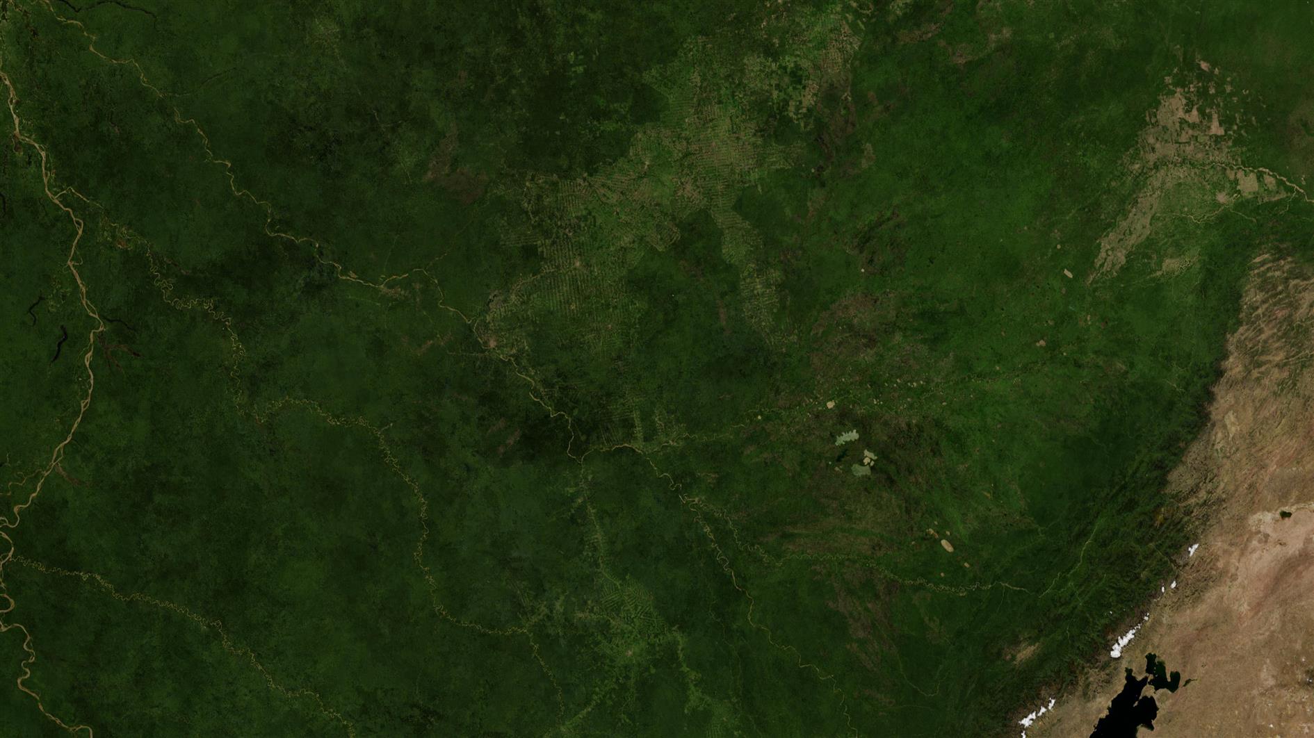
This animation shows twelve sections from the highest resolution version of NASA's Blue Marble Next Generation image for December 2004.
Can you guess all twelve locations? Answers below.
I use a lower resolution version of this image in Catfood Earth. The full version is 86,400 by 43,200, or 3.7 gigapixels. I've always wanted to do something with all this data, and decided to just follow some random paths and animate out the results. It's a little like watching the view from the ISS, if the ISS could randomly change location and direction.
The sequences in order are:
- Passing over Madagascar and then across central Africa.
- Along the Aleutian Islands and into Alaska.
- Across South America and the Amazon.
- Up the Eastern seaboard of the US into Canada.
- Following the Nile through North Africa.
- From Siberia to Denmark.
- Up Baja California and then California USA.
- Philippines, Taiwan, China, Mongolia.
- Following the Caribbean to Florida.
- Across Australia.
- South South America, focused on Chile.
- Koreas, Japan.
Related Posts
You Might Also Like
- Send event parameters with every event and multiple tags in Google Analytics 4
- Resist Report
- Why Microsoft is Likely Doomed Based on one Email Folder
(Published to the Fediverse as: Blue Marble 2 Animation #etc #video #nasa #bluemarble #earth #satellite 4k 60fps video from high resolution satellite imagery, can you guess all twelve locations? )
Animation of a year of Global Cloud Cover
Update April 19, 2020: I made a longer, higher resolution version which you can find here.
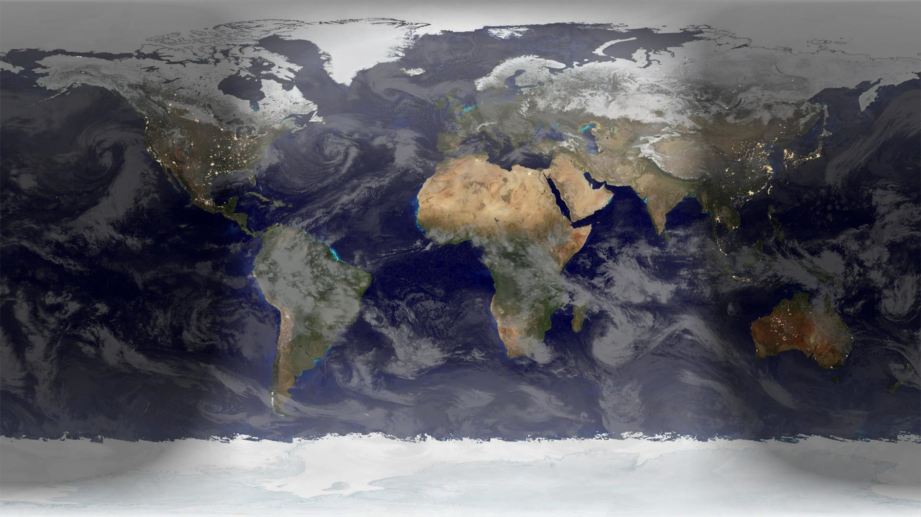
Here's an animation showing a year of global cloud cover (from July 2017 to July 2018) :
The clouds are sourced from the free daily download at xplanet. I run a Google apps script that saves a copy of the image to Google Drive every day (basically the same as this script to save Nest cam images). The hard part was waiting a year to get enough frames. Xplanet combines GEOS, METEOSAT and GMS satellite imagery with some reflection near the poles. Although I didn't need to for this project note that you can subscribe to higher quality / more frequent downloads.
As well as the clouds you can also see the terminator between day and night change shape over the course of the year. This video starts and ends with the Summer equinox when days are longest in the Northern hemisphere.
Where it's nighttime the image is based on NASA's Black Marble. The daytime is based on Blue Marble, but blended with a different older image which has better ocean colors and interpolated daily between twelve monthly Blue Marble satellite images. The result of this is that you can see snow and ice coverage changing over the course of the year. If you look closely you'll also notice vegetation growing and dying back with the seasons.
Rendered in a slightly modified build of Catfood Earth (the main release doesn't know how to access my private cache of xplanet cloud images). As well as combining day, night and cloud images Catfood Earth can also show you earthquakes, volcanoes, US weather radar, political borders, places and time zones. It has been enlivening Windows desktop wallpaper for fifteen years now (as shareware back when that was a thing, these days it's a free download for Windows and Android).
More Google Apps Script Projects
- Get an email when your security camera sees something new (Apps Script + Cloud Vision)
- Get an email if your site stops being mobile friendly (no longer available)
- Export Google Fit Daily Steps, Weight and Distance to a Google Sheet
- Email Alerts for new Referers in Google Analytics using Apps Script
- Control LIFX WiFi light bulbs from Google Apps Script
- How to backup Google Photos to Google Drive automatically after July 2019 with Apps Script
- Using the Todoist API to set a due date on the Alexa integration to-do list (with Apps Script)
- Automate Google PageSpeed Insights and Core Web Vitals Logging with Apps Script
- Using the Azure Monitor REST API from Google Apps Script
- Monitor page index status with Google Sheets, Apps Script and the Google Search Console API
(Published to the Fediverse as: Animation of a year of Global Cloud Cover #code #software #video #animation #appsscript #drive #earth #nasa #xplanet Timelapse video showing cloud cover, day and night and changing seasons. Rendered in Catfood Earth. )