Salt Point State Park

By Robert Ellison. Updated on Wednesday, February 22, 2017.

Salt Point State Park

Salt Point State Park

Salt Point State Park

Salt Point State Park

Salt Point State Park on the Sonoma coast. Stunning views, plentiful seals and some cool tide pools (although the rocks on the way down are like greased butter). Apparently the sandstone from Salt Point was used to pave San Francisco which goes a long way to explain the state of the streets...

Hike starts at 38.566568, -123.331860 (Google Earth, Google Maps).

Add your comment...

Related Posts

(Hike Map)

(Published to the Fediverse as: Salt Point State Park #hike #saltpoint #seal #hermitcrab A short hike and some photos at Salt Point State Park in Sonoma County, California. )

Wave Organ

By Robert Ellison. Updated on Friday, February 24, 2017.

The Wave Organ, San Francisco

Like the Internet, The Wave Organ is a series of tubes. Unlike the Internet it groans at you in different ways as the tide comes in and out. It’s also a nice walk on a blustery day with great views around the bay and back over to the Marina.

Kate at The Wave Organ in San Francisco

(Google Earth KML, Google Maps)

Hike starts at: 37.806707, -122.446921.

Add your comment...

Related Posts

(Hike Map)

(Published to the Fediverse as: Wave Organ #hike #sanfrancisco #waveorgan Hike to visit The Wave Organ in San Francisco, California. It makes an exciting variety of sounds depending on what the tide is up to. )

Sweeney Ridge

By Robert Ellison. Updated on Thursday, November 12, 2015.

Sweeney Ridge, starting from Skyline College and walking up to the Portola Expedition Monument and back again.

(Google Earth KML)

Hike starts at: 37.62864, -122.463666.

Add your comment...

Related Posts

(Hike Map)

(Published to the Fediverse as: Sweeney Ridge #hike #sweeneyridge #ggnra Bay Area hike up Sweeney Ridge to the Portola Expedition Monument (part of the Golden Gate National Recreation Area). )

Sentinel Dome

By Robert Ellison. Updated on Friday, February 24, 2017.

Sentinel Dome Route

Slightly easier than Half Dome, and when you get to the top you get to look at Half Dome. What more could you ask for!

Rob & Kate approaching the top of Sentinel Dome in Yosemite National Park

(View in Google Earth)

Hike starts at: 37.715495, -119.584577.

Add your comment...

Related Posts

(Hike Map)

(Published to the Fediverse as: Sentinel Dome #hike #sentineldome #yosemite Spectacular views from this hike to the top of Sentinel Dome in Yosemite National Park, California. )

Black Diamond Mines Regional Preserve

By Robert Ellison. Updated on Monday, May 24, 2021.

Black Diamond Mines Regional Preserve

Black Diamond Mines Regional Preserve is an East Bay park spanning more than five thousand acres.

I spotted what looked like an easy four mile loop. It was nearly seven, I guess all the .3’s really do add up. The loop we did was a mix of exposed sunny ridgelines and shady canyons. We went on a ‘cold’ day which was still high 80s and a nice sweltering break from the San Francisco fog.

Kate; Jim's Place

Kate taking a break outside of ‘Jim’s Place’.

Gill & Kate

Gill and Kate, again outside of' ‘Jim’s Place’.

Gill; Pittsburg an the California Delta

Gill with a view to Pittsburg and the California Delta.

(View in Google Earth (KML))

Hike starts at: 37.958487, -121.862883.

Add your comment...

Related Posts

(Hike Map)

(Published to the Fediverse as: Black Diamond Mines Regional Preserve #hike #blackdiamondmines Seven mile hike in the Black Diamond Mines Regional Preserve in Antioch, California. )

Lake Merritt

By Robert Ellison. Updated on Saturday, May 8, 2021.

Lake Merritt, Oakland, CA Hike on May 5, 2011

The path around Lake Merritt is a pleasant hour-ish hike in downtown Oakland. In addition to a startling variety of waterfowl (apparently it’s the first official wildlife refuge in the US) Lake Merritt is the home of Fairyland which I fear I may be forced to visit in the not to distant future.

Birds at Lake Merritt

Lake Merritt, Oakland, CA

Lake Merritt, Oakland, CA

(3.76 miles, 1 hour 2 minutes, average 3.64 mph, view in Google Earth).

Hike starts at: 37.808922, -122.263224.

Add your comment...

Related Posts

(Hike Map)

(Published to the Fediverse as: Lake Merritt #hike #oakland #lakemerritt Hike around Lake Merritt in Oakland, California. Around an hour, just under 4 miles. )

Twin Peaks

By Robert Ellison. Updated on Sunday, May 3, 2020.

Twin Peaks

Not much of a hike, but Twin Peaks is about as high as you can get in San Francisco and offers wonderful views on a clear day or night. Park here and then escape the throngs by walking up one or both of the peaks.

Rob and Kate at the top of Twin Peaks in San Francisco
We often take guests from out of town up Twin Peaks. The occasion today was a first visit for a new native San Franciscan – Katherine Harper Ellison – seven days old on her first trip up to the top of Noe Peak.

Red-tailed Hawk above Twin Peaks in San Francisco 
A Red-tailed Hawk hunting over Twin Peaks.

(.49 miles, total elevation gain 201 feet, 25 minutes, average 1.17 mph, view in Google Earth.)

Hike starts at: 37.754849, -122.446607.

Add your comment...

Related Posts

(Hike Map)

(Published to the Fediverse as: Twin Peaks #hike #twinpeaks #sanfrancisco Short hike up Twin Peaks in San Francisco, California. )

Golden Gate Park - Stow Lake, Strawberry Hill and Museum Concourse

By Robert Ellison. Updated on Saturday, July 18, 2020.

Golden Gate Park - Stow Lake, Strawberry Hill and Museum Concourse

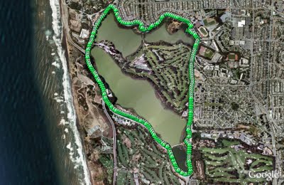
An alternative to our normal loop is another three mile walk starting from JFK and Transverse. Instead of heading towards the beach walk up under the bridge and take the first right to Stow Lake.

Stow Lake

Stow Lake surrounds Strawberry Hill. There's a path around the lake with two bridges leading to the hill. I normally walk to one bridge, cross and then up to the top of the hill. It's generally pretty quiet with great city and ocean views in between the trees.

Top of Strawberry Hill in the middle of Stow Lake

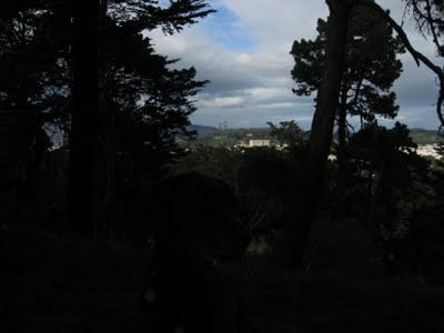
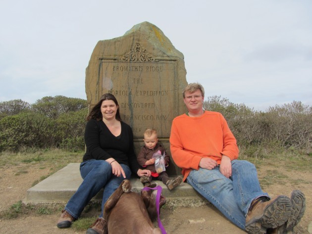
View from the top of Strawberry Hill. Rudy is in there somewhere, click for a larger version.

de Young Museum

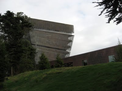
After the hill I walk over to the Museum Concourse. The de Young rises through the trees like an implausibly stranded copper aircraft carrier. It hosts a range of paintings, decorative art, sculpture and modern art. You're bound to find something you like here.

de Young Museum (Side)

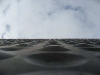
The copper cladding will turn green eventually, probably before the new Bay Bridge span is finished.

California Academy of Sciences

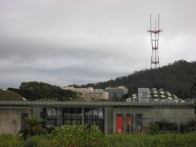
Opposite the de Young is the California Academy of Sciences. The Academy features an outstanding digital planetarium, a three story rainforest and an aquarium. It reopened last year after a major rebuild and it's insanely popular - get there first thing to snag the first come first served planetarium tickets.

Prayerbook Cross

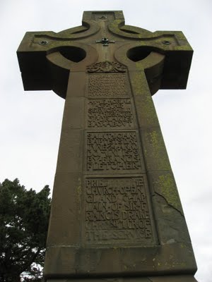
On the way back I detoured up to Prayerbook Cross, donated in 1894 to commemorate the first English sermon on the pacific coast after Sir Francis Drake discovered Drake's Bay (a name which didn't stick).

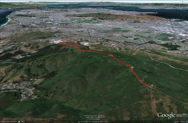
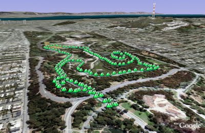
(2.97 miles, total elevation gain 103 feet, 1 hours, 17 minutes, average 2.29 mph, view in Google Earth, view in Google Maps.)

Hike starts at: 37.770433, -122.479941.

Add your comment...

Related Posts

(Hike Map)

(Published to the Fediverse as: Golden Gate Park - Stow Lake, Strawberry Hill and Museum Concourse #hike #sfdogwalk Three mile hike in Golden Gate Park taking in Stow Lake, Strawberry Hill and the Museum Concourse (San Francisco, California). )

Lake Merced

By Robert Ellison. Updated on Tuesday, June 20, 2023.

Lake Merced

Lake Merced is a natural lake near Fort Funston. It used to be San Francisco's main fresh water supply but is now the emergency reserve (somewhat worrying as a previous earthquake caused much of Lake Merced to drain into the Pacific).

The lake is also the site of the Terry/Broderick duel where in 1859 the Chief Justice of the California Supreme Court (Terry) killed a US Senator (Broderick) in an argument over slavery.

The loop around the lake is a flat five mile path, unfortunately marred by heavy traffic and constant gunfire from clay pigeon shooting and/or the SFPD firing range.

Rob and Rudy at Lake Merced

Rob and Rudy at Lake Merced.

Penguin's Prayer

Gill and Rudy next to a sculpture called "Penguin's Prayer". Given the latitude I expect the penguin is praying for the next ice age.

(4.85 miles, total elevation gain 0 feet, 1 hour, 39 minutes, average 2.93 mph, view in Google Earth, view in Google Maps.)

Hike starts at: 37.712302, -122.489232.

Updated 2023-06-20 01:27:

Video from a trip round Lake Merced on June 19, 2023.

Add your comment...

Related Posts

(Hike Map)

(Published to the Fediverse as: Lake Merced #hike #sfdogwalk #video #hikevid Five mile hike around Lake Merced in San Francisco, California. )

Año Nuevo

By Robert Ellison. Updated on Saturday, February 19, 2022.

Año Nuevo

We decided to visit Año Nuevo State Natural Reserve today because it's one of the hundreds of California state parks threatened with closure by Governor Arnold Schwarzenegger's proposed cuts.

The main attraction of Año Nuevo is the presence of a large colony of elephant seals. At this time of the year you walk a couple of miles where volunteers are available to answer questions and lend binoculars. In the breeding season between December and March you need to book a guided walk at least a day in advance - or at least you will if the park survives.

(As well as my video, check out the streaming Sealcam on Año Nuevo Island.)

Elephant Seals at Año Nuevo

Elephant Seals at Año Nuevo.

Gill with Año Nuevo Island in the background

Gill, with Año Nuevo Island in the background. You can see the ruins of a lighthouse on the island (click the image for a larger version). The original name dating back to 1603 is La Punta de Año Nuevo or New Year's Point (much erosion since then).

A Lizard

One of many lizards encountered on the trail.

(4.18 miles, total elevation gain 268 feet, 1 hour, 48 minutes, average 2.32 mph, view in Google Earth, view in Google Maps.)

Hike starts at: 37.12086, -122.307237.

Add your comment...

Related Posts

(Hike Map)

(Published to the Fediverse as: Año Nuevo #hike #anonuevo #lizard #seal #elephantseal #video Four mile hike to see Elephant Seals at Año Nuevo State Park in San Mateo County, California. )