Oakland Hills
By Robert Ellison. Updated on
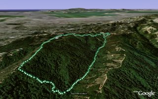
Quick walk around the Oakland Hills, no photos this time.
(4.68 miles, total elevation gain 2,697 feet, 2 hours 3 minutes (average 2.28 mph), view in Google Earth)
Hike starts at: 37.830983, -122.18615.
Updates
Oakland Hills (Longer Walk)
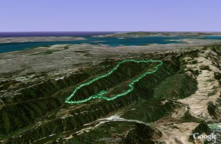
Longer walk in the Oakland Hills, up the East ridge and then back down the West ridge.

(8.63 miles, total elevation gain 3,976 feet, 3 hours 1 minutes (average 2.86 mph), view in Google Earth)
Hike starts at: 37.806533, -122.148783.
Add Comment
All comments are moderated. Your email address is used to display a Gravatar and optionally for notification of new comments and to sign up for the newsletter.