Links for October 2022
By Robert Ellison.
SFGATE: Skyscraper with floating cube might come to San Francisco
This is an incredibly bad idea for a city with a record for skyscrapers that don't stand up straight...
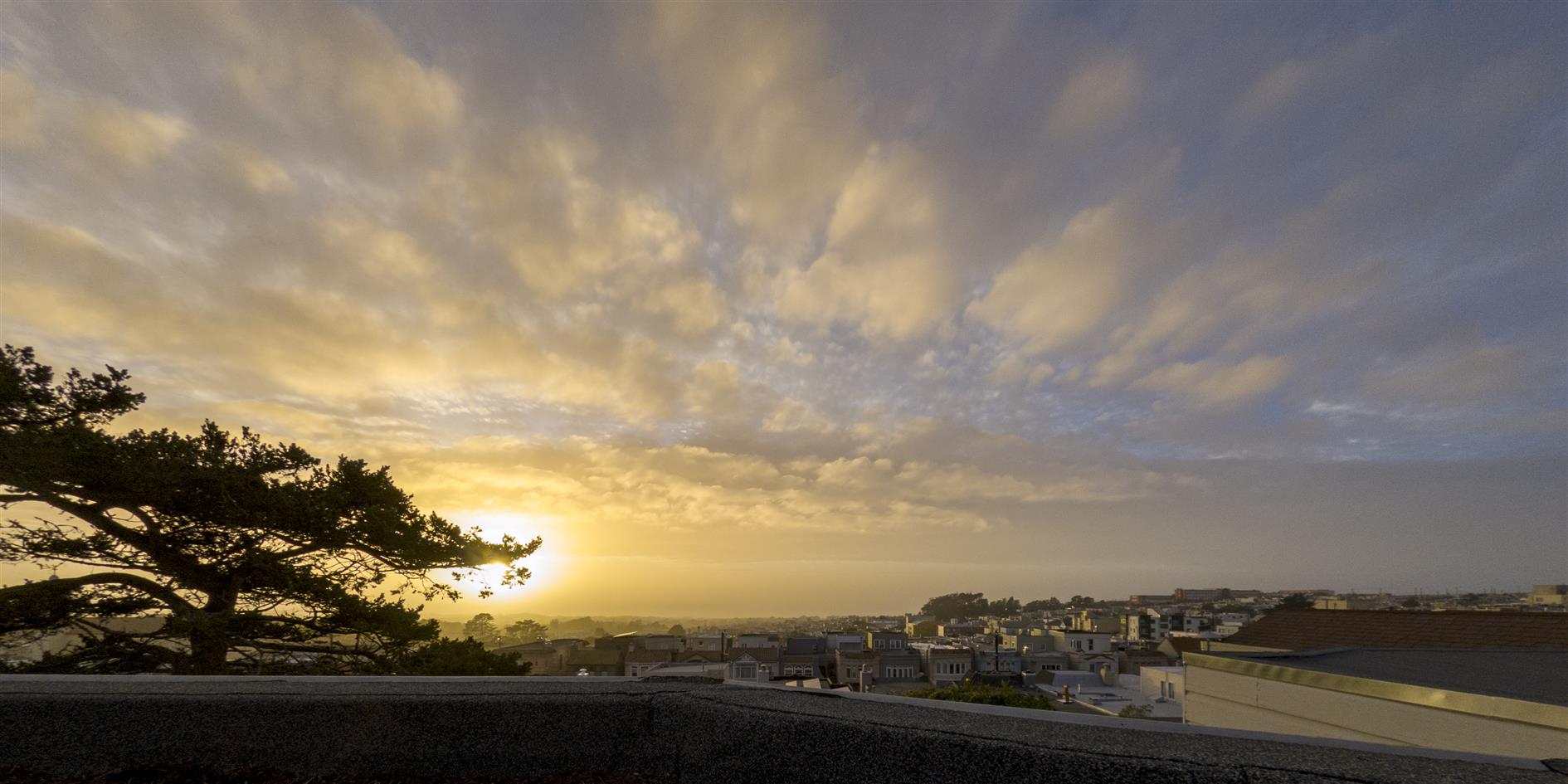
Four time lapse sequences of cool clouds over San Francisco at sunset following the January 2022 sequence of atmospheric rivers.
(Published to the Fediverse as: Timelapse of San Francisco Clouds After Various Atmospheric Rivers #timelapse #video #clouds #sanfrancisco #sunset #4k Post atmospheric river (January 2022) sunset time lapse from San Francisco, California. )
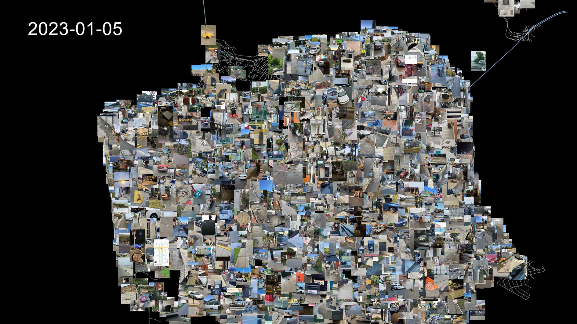
This animation shows a random sample of 311 cases that have a photo and specific location. It covers July 4, 2013 to January 5, 2023. Created using the 311 dataset plotted over a street map of San Francisco.
(Published to the Fediverse as: San Francisco 311 Cases Animation #etc #video #animation #sanfrancisco #311 Animation of a sample of San Francisco 311 cases from 2013 to 2023 (photo and location) )
SONY ILCE-7C 20mm f1.8 1/320s ISO100
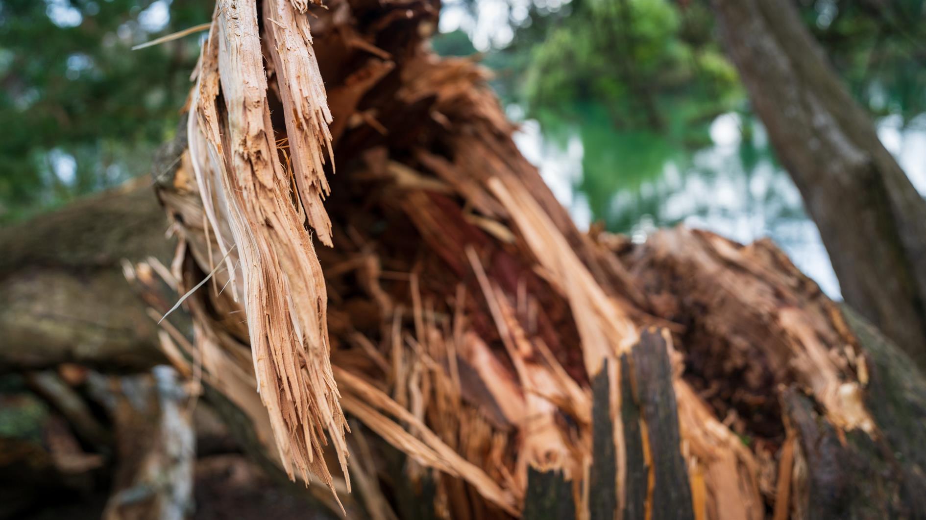
Photo of the twisted wreckage of a tree on Strawberry Hill in the middle of Stow Lake (Golden Gate Park, San Francisco).
(Published to the Fediverse as: After the Storm #photo #tree #strawberryhill #stowlake #sanfrancisco #ggp A photo of a downed tree on Strawberry Hill in Stow Lake, Golden Gate Park, San Francisco. )
SONY ILCE-7C 20mm f3.5 1/160s ISO100
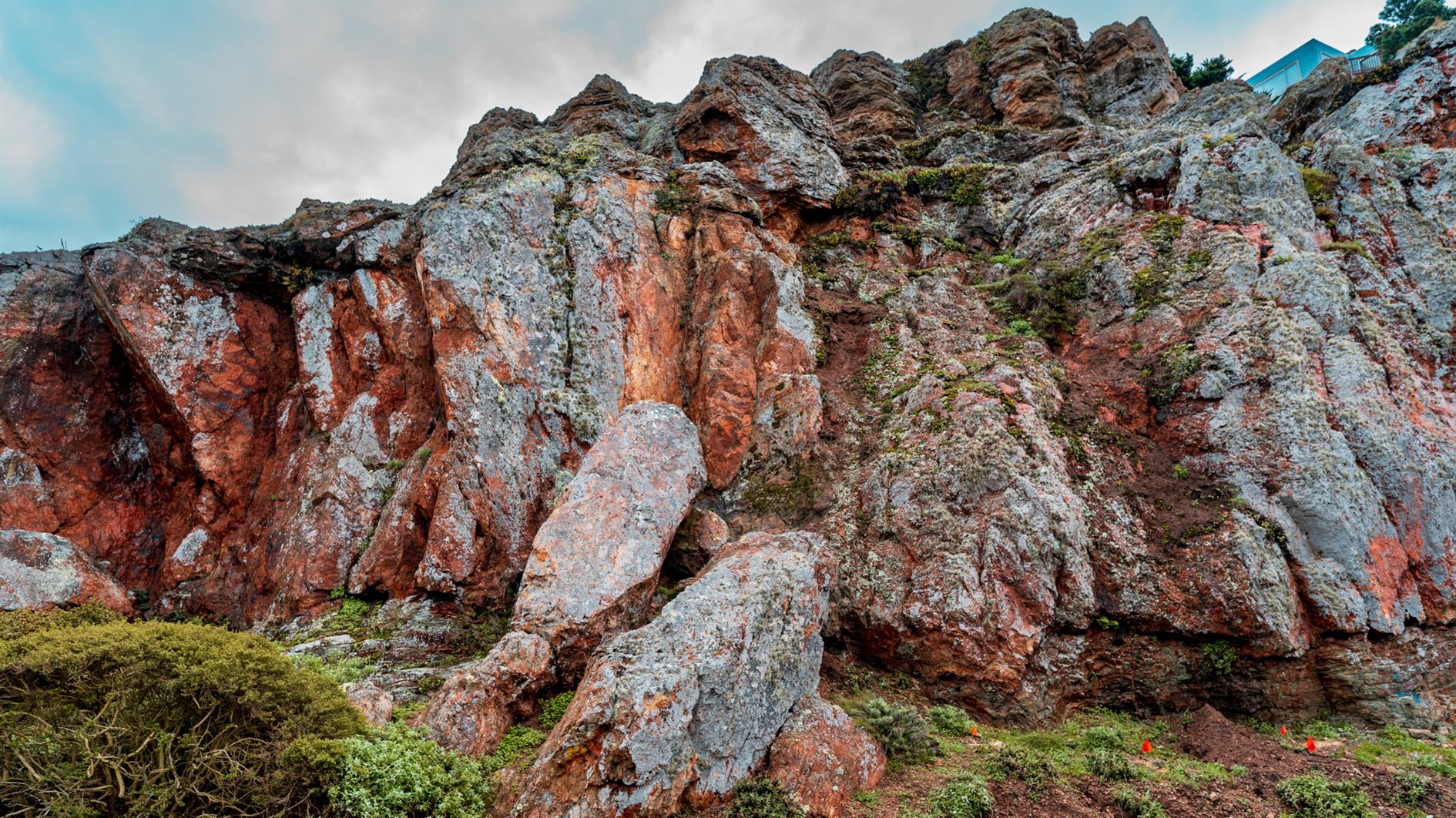
Photo of Rocky Outcrop Park in San Francisco. 14th Avenue next to this urban cliff is usually a wind tunnel.
(Published to the Fediverse as: Rocky Outcrop Park #photo #rockyoutcrop #sanfrancisco Dramatic colors in this photo of Rocky Outcrop Park in San Francisco, California. )
Testing out some shapefile code with a zoom into San Francisco. This uses five different shapefiles:
Country borders are from Eric Muller's fips-10 shapefile.
States and US Counties come from the United States Census Bureau.
San Francisco 5 foot elevation contours from DataSF.
Finally the street map for San Francisco is from data.gov.
These are almost all based on different projections and I did my best to actually line everything up but if you're heading over for coffee it's probably best to stick with Google Maps.
(Published to the Fediverse as: Assassination Coordinates #etc #video #sanfrancisco #shapefile #animation Animation that zooms from a global map to the streets of San Francisco using five different shapefiles. )

Time lapse of a Boeing 777-300ER landing at San Francisco International Airport (SFO).
Shot on a Pixel 6 Pro in 10x timelapse mode wedged into a window with the blind closed. I thought I'd just get some clouds but happily the crew didn't force us to open all the blinds, so the video shows us entering California with heavy clouds (a plane with contrails going the other way right at the start), clouds clearing as we cross California and then the full landing. Bit of dirt on the window unfortunately but still quite happy with the result. The flight was from Frankfurt.
(Published to the Fediverse as: Landing at SFO #timelapse #video #sfo #sanfrancisco #plane Time lapse video of a Boeing 777-300ER landing at SFO. )
Google Pixel 6 Pro 19mm f3.5 1/280s ISO33
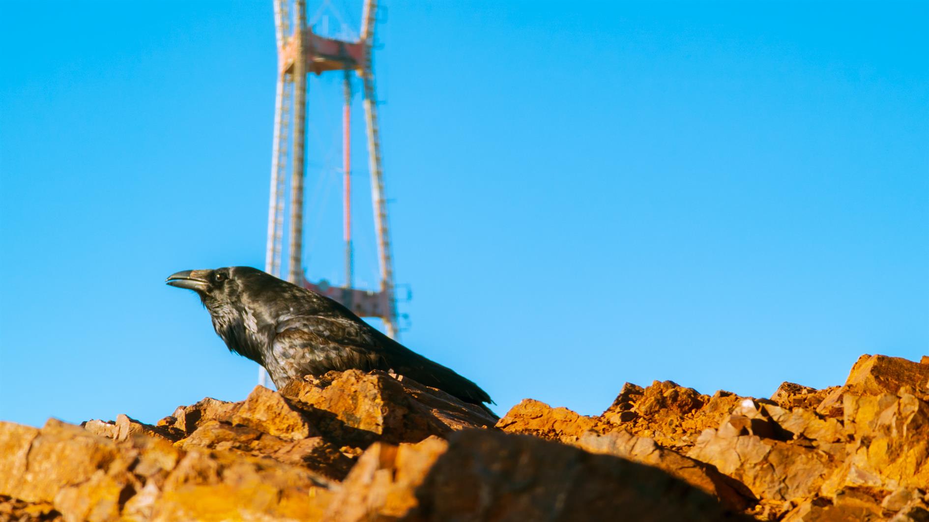
Photo of a crow in front of Sutro Tower at Twin Peaks in San Francisco.
(Published to the Fediverse as: Crow, Sutro Tower #photo #crow #sutrotower #twinpeaks #sanfrancisco A crow in front of Sutro Tower at Twin Peaks in San Francisco, California (Photo). )

I am enjoying this interactive map of San Francisco's Board of Supervisors Districts way too much, because it raises more questions that it answers.
List most (many? some?) San Franciscans I'm used to seeing the Supervisorial Districts on a land map of the city, maybe with a shout out to Treasure Island. In 2022 these districts were redrawn with some local drama - a few blocks moved from District 4 to District 7 and vice versa. But I saw no coverage whatsoever of the maritime impact of this process.
When you load the map you probably immediately notice the imperial reach of District 6, sweeping up to the Richmond Bridge and nudging aggressively against Oakland and Alameda. District 2 is brazen in its denial of any part of the Golden Gate to Marin County. But to appreciate the full scope you need to zoom out enough to see that District 4 encompasses the Farallon Islands and surrounding waters, making it the largest district by a pretty good margin. Although it probably also means that it contains more mice than people.
Why are the Farallon Islands in District 4? It looks like these should be a territory of District 7 (this is my district and I'm feeling envious as the Islands are straight out to sea from my house). Things get weird when you go back to the map of 2011 districts. Back then, District 4 had a tiny slice of water off of Ocean Beach, but District 1 extended north and south plugging the Golden Gate and abutting District 7's territorial waters. The Farallon Islands were still part of the city but not demarcated by the map.
So with all the drama around moving a few houses between Supervisors, how was there time for such a maritime land grab by District 4? How did District 1 lose its stranglehold on traffic into the Bay? Why was any of this changed at all? Some half hearted Googling produced no answers. If you know, please leave a comment and if I find out I'll report back.
(Published to the Fediverse as: Why did San Francisco Redistrict the Pacific? #politics #sanfrancisco The 2022 San Francisco Board of Supervisors redistricting included some unexpected maritime changes including a massive transfer of territory from District 1 to District 4. )
My guide to all fourteen ballot measures for San Francisco in November 2022. Hot on the heels of 8 in June. My overriding principle here is to prevent the need for future ballot measures although I can't help myself from indulging in the occasional good idea.
Yes. This is cheap and makes retirement benefits for city workers more fair and predictable.
No. We just voted to create a department of sanitation and streets in 2020.
Yes. More oversight for spending on homeless services.
Yes. Makes it easier to build new housing in San Francisco. Seems to cut a lot of unnecessary red tape to get projects moving faster.
No. This competes with D to try and avoid losing too much control.
No. I'm not anti-library, but I am opposed to ballot measures that carve out specific funding and then will need another ballot measure if anything needs to change.
No. Another set aside that can't be undone without a future ballot measure.
Yes. Increased voter turnout should lead to more representative local officials. I thought I voted for this already in 2012? Unfortunately this measure also has an adjustment to keep the number of signatures required for a new ballot measure constant. I'd love to see it get harder.
No. Let's keep some car free space.
Yes. As above.
Yes. Extends an existing sales tax for transportation.
No. Could discourage new housing from being built and as written does not apply equally to all housing.
Yes. I need to make decisions about a single parking garage? This would allow the city more control, and as I want to keep JFK car free it makes sense to optimize this parking resource for people who will have more difficulty getting to the museums as a result.
Yes. This is an important resource and we need to get it back on track.
(Published to the Fediverse as: San Francisco November 2022 Ballot Measures #politics #sanfrancisco #propositions #election The official ITHCWY voter guide to San Francisco's 2022 ballot measures. )
SFGATE: Skyscraper with floating cube might come to San Francisco
This is an incredibly bad idea for a city with a record for skyscrapers that don't stand up straight...
Export Google Fit Daily Steps, Weight and Distance to a Google Sheet
Download a Sharepoint File with GraphServiceClient (Microsoft Graph API)
Which PG&E rate plan works best for EV charging?
Monitor page index status with Google Sheets, Apps Script and the Google Search Console API
International Date Line Longitude, Latitude Coordinates
Accessing Printer Press ESC to cancel
Is it safe to open securedoc.html (Cisco Registered Envelope)?