By Robert Ellison. Updated on Tuesday, January 25, 2022.
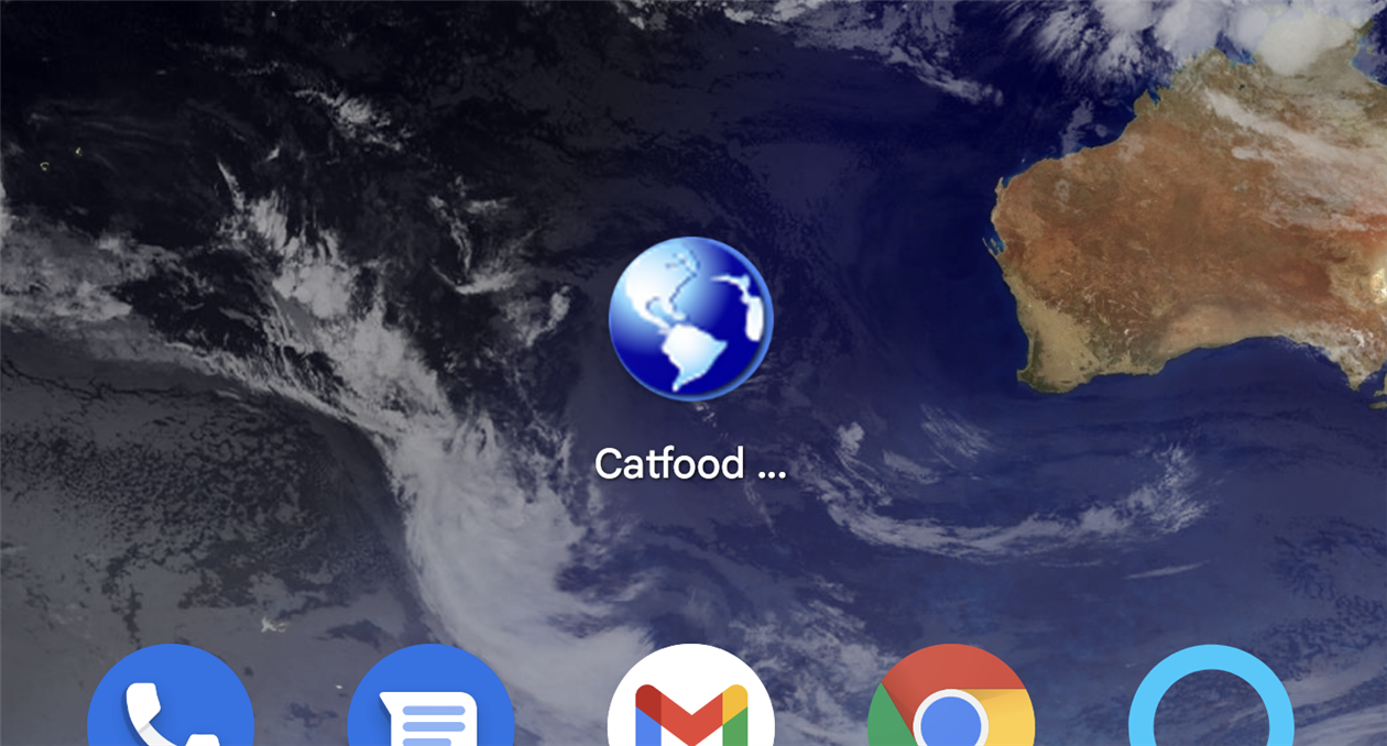
Catfood Earth for Android 4.20 adds support for Material You, the custom color scheme introduced in Android 12. By default every wallpaper update will also subtly change your system color palette. You can override this from settings -> Wallpaper & style and switch back to basic colors if you don't like the Catfood Earth colors. This update was surprisingly painful. You can install Catfood Earth from Google Play, or for existing users it will automatically update in the next day or so.
By Robert Ellison. Updated on Monday, September 29, 2025.
I have been trying to update Catfood Earth for Android to support Material You in Android 12. This sets a color palette from your wallpaper and other than making notifications harder to manage seems to be the main thing that Google has been working on for the past year. Live wallpaper isn't automatically supported, it's up to you to tell the system about your colors.
Happily there is an overridable OnComputeColors in WallpaperService.Engine, and you can create a WallpaperColors object from a bitmap so this looked like a five minute update. Hahahahahahhahahahah.
I spent a few weeks waiting for the Android 12 SDK to be available in Xamarin. I found some pointers to their GitHub and assumed it would show up there and so waited a few weeks. It still isn't there. I found some article about forcing it to install in Visual Studio 2019 that didn't work for me, and then realized that Visual Studio 2019 update checks were crashing. While trying to fix that I found that Visual Studio 2022 has been released and this installs with the Android 12 SDK!
These days I work on side projects when I get the occasional free hour. Almost inevitably that hour is consumed with updating two or three things and then hoping that the next time I get some time at least I'll be ready to go. But when that hour arrives I'm back to updating again.
So finally I have the right SDK and drop in an OnComputeColors and a call to NotifyColorsChanged when my wallpaper is updated. Time to start testing. The good news is that Material You is now working with Catfood Earth selected as the current wallpaper. The bad news is that every time I call NotifyColorsChanged the launcher disappears and I'm just left with the wallpaper and no icons or search box. Probably not a good experience. I try moving the NotifyColorsChanged call around to different points in code and it makes no difference. This simple update is rapidly spiraling from minutes to days to weeks.
Maybe it's some Xamarin bug, or something in Android 12 or maybe a change in the solemn contract between live wallpaper services and the rest of the system. Can't find any hint of any of this on the Internet.
It's also possible that the bitmap I'm passing is too large or too complex or too something else. So let's try just sending back a simple WallpaperColors in OnComputeColors and see if that helps.
The Android documentation for WallpaperColors suggests that you can construct it from three colors which seems sensible. The Xamarin implementation takes ColorObject instead of Color. What is a ColorObject? The sparse Xamarin documentation suggests that it has an empty constructor that creates an opaque black color and then properties like Red that are read only. So an immutable black? That can't be right? When constructing a color the constructor would seem like a great place to tell the class what color it is. Failing that, a FromColor or FromArgb would seem to follow the right sort of convention. But no. You need to find ValueOf. To create a color that is a class and not a value. Sigh. Maybe that is some kind of deep Android convention that I would just know if I did this more often than once a year or so.
Although, maybe most Google Developers can't figure out how to make a non-black color and that's the origin of Material Design 2. Everything else is just marketing rationalization on top of a terrible API.
Finally I have a simple WallpaperColors to test with but my build has broken. At some point while figuring out how to get a ColorObject that isn't black I thought a NuGet package would help. My project is now completely broken. My experience with touching NuGet is that you can either spend several days unpicking the carnage or just start over. Git reset --hard HEAD it is then.
After quickly reimplementing the changes so far, returning a vanilla WallpaperColors object works... and so does the FromBitmap version. So 90% chance that I bodged something subtle the first time and didn't make the mistake on the second pass. 10% chance it was something strange in Visual Studio.
(Published to the Fediverse as:
The Secret Diary of a Xamarin Android Developer, Aged 48 1/3 #code#android#xamarin#catfood#earth An adventure in persuading Android live wallpaper to support Material You colors via the magic of Xamarin and weeks of frustration.)
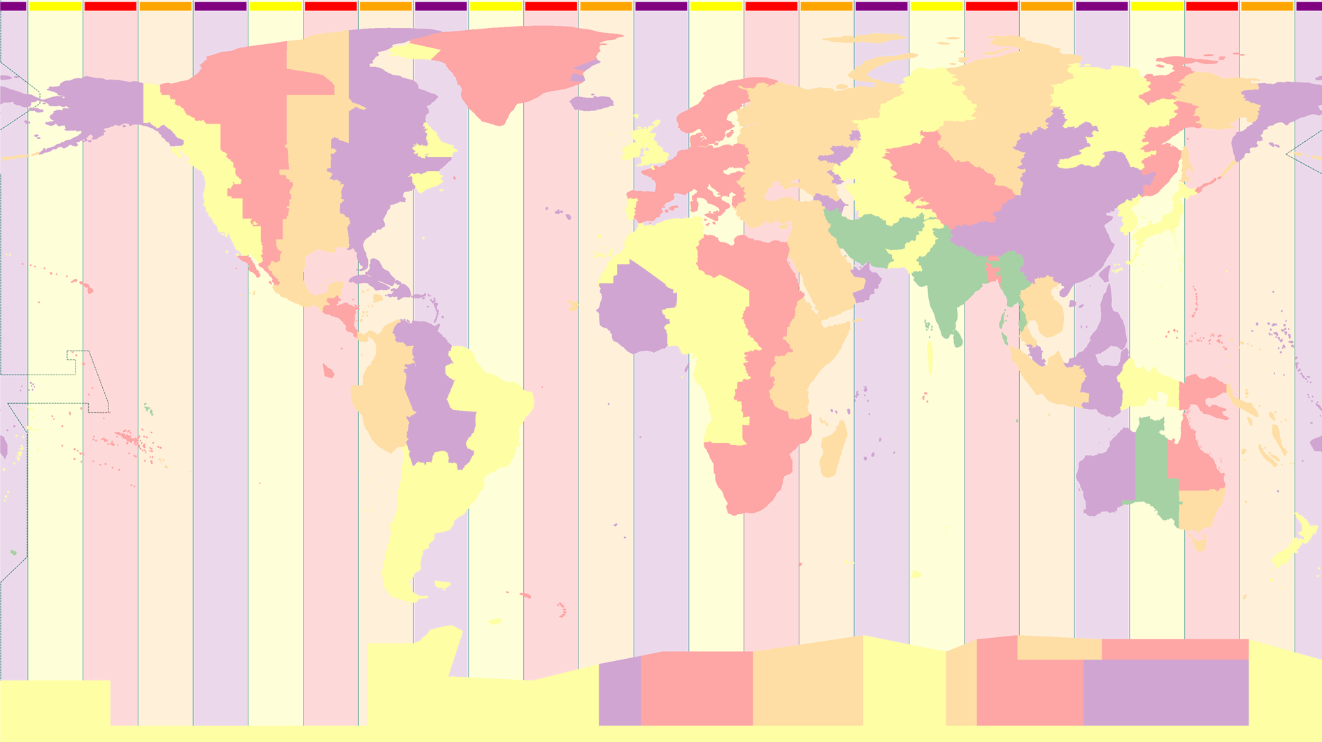
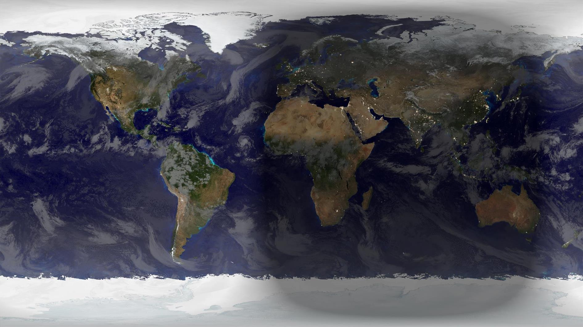
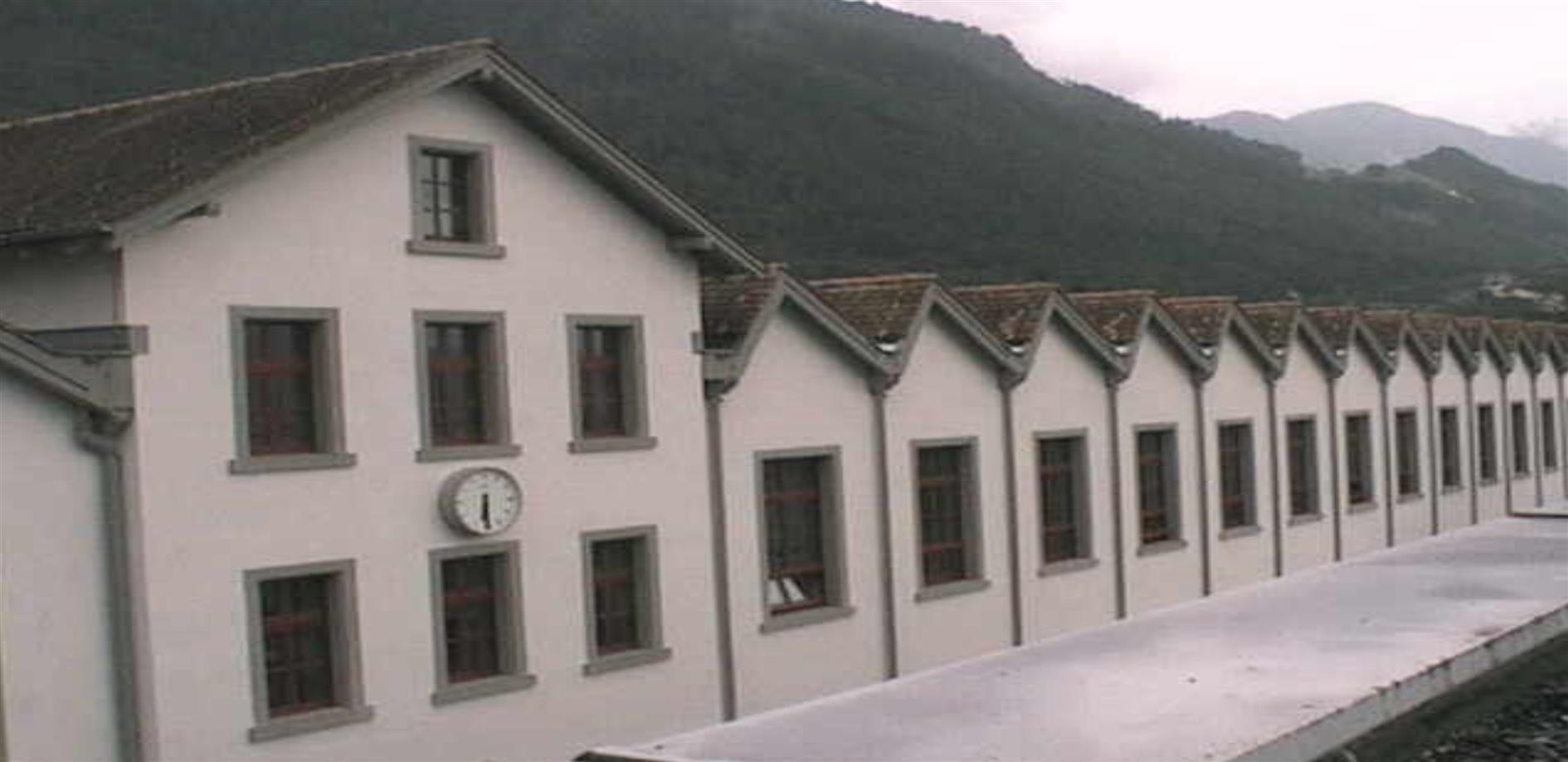
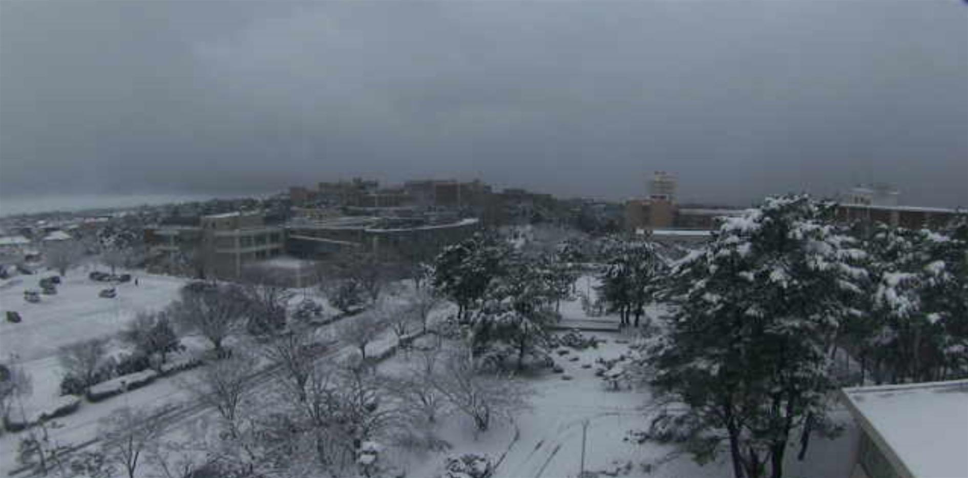
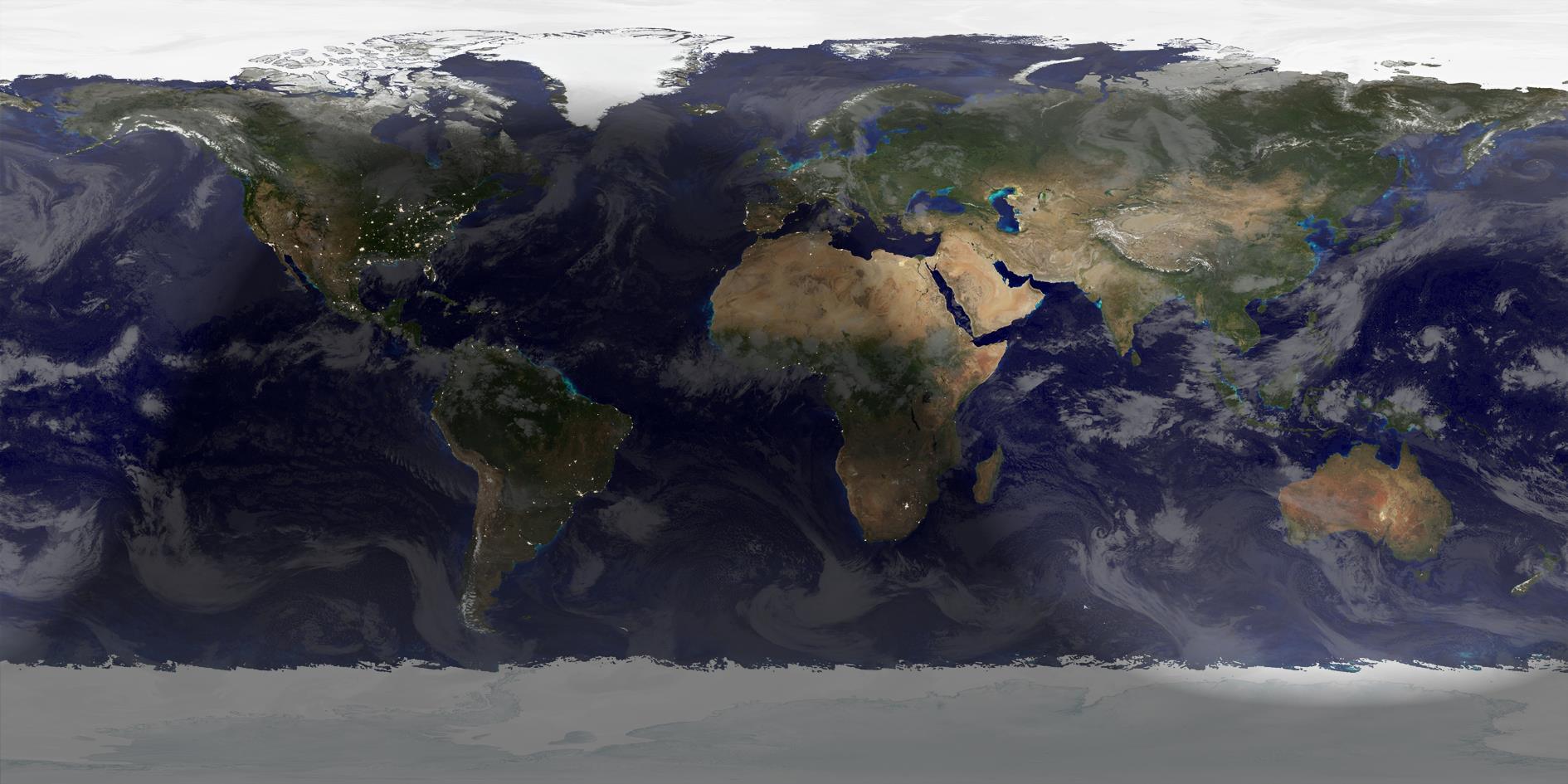
Winter Solstice 2021 rendered in Catfood Earth (15:59 UTC, December 21, 2021). Winter begins in the northern hemisphere, summer if you happen to be south of the equator.
By Robert Ellison. Updated on Saturday, February 19, 2022.
Catfood WebCamSaver 3.26 is available to download.
This update includes the latest list of webcams. It has also been updated to use .NET 4.8 which means it will install with no additional downloads needed on Windows 10 and 11. The installer is now signed. You might get a warning from Defender about the program being infrequently used, you will need to ignore this to install. Lastly WebCamSaver will now automatically check for updates so you'll get a desktop notification when a new version is available.
This update includes the 2021d time zone database.
After procrastinating for far too long I have also migrated to .net 4.8 and renewed my code signing certificate. You'll get at least one less warning when installing and you no longer need to enable .net 3.5 on Windows 10 which was a pain. This shouldn't make any difference but please let me know if you have any trouble installing or running this version.
Catfood WebCamSaver is a Windows screen saver that streams live views from random webcams around the world. Download for Windows. You can choose to display 1, 4 or 16 webcams at the same time, and WebCamSaver fully supports multiple monitors. Catfood WebCamSaver was first released in 2004.
When you install Catfood WebCamSaver a shortcut is created to Screen Saver Settings. You can search for Catfood WebCamSaver Settings and run the shortcut, or open Screen Saver Settings directly (on Windows 10, Start -> Settings -> Personalization -> Lock screen -> Screen saver settings). From Screen Saver Settings make sure that Catfood WebCamSaver is selected and then click Settings. On the Windows settings dialog you can also choose how many minutes to wait before starting the selected screen saver and if the login screen should be displayed when the screen saver exits.
Catfood WebCamSaver Settings has three tabs:
General
Under Description choose if the description of the webcam and the local time if available should be displayed. Click Font to pick the font, color, and optional outline color to use for the description and time.
Under Display choose the number of webcams to show at the same time (1, 4 or 16), how often to switch to a new webcam and how often to refresh the webcam image.
Under Offline Display you can choose a fallback screensaver to start if the Internet is not available.
Webcams
Please note that recent releases of WebCamSaver will delete and recreate the webcam list on install. This means you will lose any customization of the list on upgrade. See the import and export instructions below to back up any changes you have made.
The Webcams list shows the current library of webcams. Click the column headers to sort (and click again to sort in the opposite direction). You can enable to disable a specific cam using the checkbox in the list.
Click Add to enter details for a new webcam.
When a webcam in the list is selected click Open to launch the web page associated with the webcam, Edit to update details or Delete to remove it from the list entirely.
Click Delete All to remove all webcams from the list.
Click Enable All or Disable All to toggle the checkboxes for all webcams in the list.
You can save your customized list by clicking Export and restore it by clicking Import.
Advanced
If you prefer day (or night) scenes you can set a local time range here. If this option is enabled webcams where the time zone is unknown will never be displayed.
Click Proxy Settings to configure a proxy server.
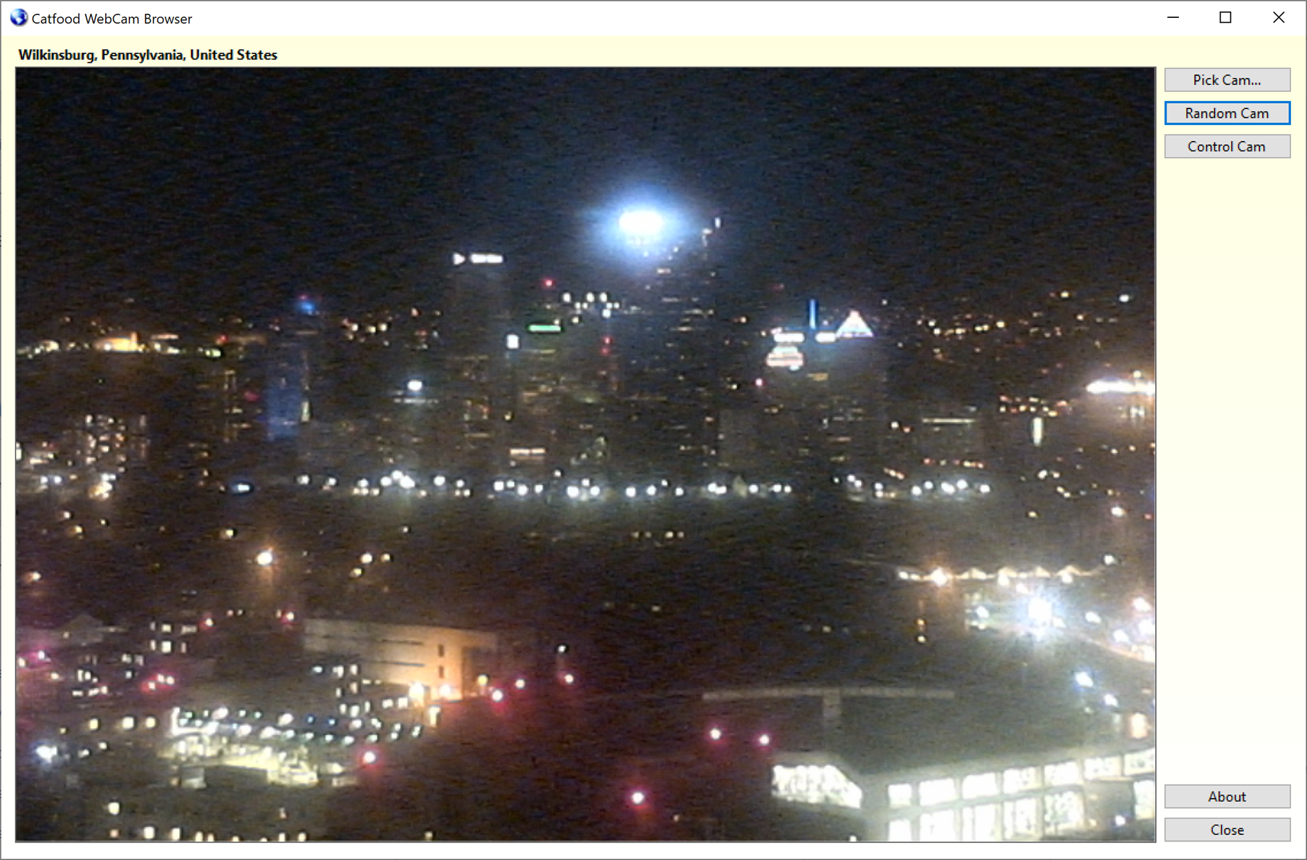
Catfood WebCam Browser
Catfood WebCam Browser is a companion application installed with WebCamSaver. When you open WebCam Browser it will start showing a random webcam from the library.
Pick Cam opens a window where you can select a webcam to view from the full list. You can sort the list (click any column header, click again to sort the opposite direction). There is also a filter that only shows webcams matching text that you enter.
Random Cam will select a new webcam at random from the list and start streaming images.
Control Cam launches a URL where you can control the currently selected webcam (if available).
About shows the version and copyright information for the application.
Installation and Support for Catfood WebCamSaver
Catfood WebCamSaver requires version 4.8 of the .NET Framework. You almost certainly have this already and the installer will download it if necessary. The installer for Catfood WebCamSaver is digitally signed. You may get a warning about it being infrequently used which you will need to ignore to install.
For support please visit this post, check to see if your issue has already been addressed and if not leave a new comment.
Customer Reviews
“We LOVE your screen saver. I've seen others try this idea, but never quite seemed to get it right.”
Buddy King
“The other day I watched as a middle aged
couple in Japan took photos of the changing orange leaves along a calm street. I saw another couple, some tourists,
digging for their sunscreen on the beach in Kona, HI.”
MIT Center for Future Civic Media Blog
“I've been fascinated by your ‘saver’! It strikes me that so many different places & cultures seem to share some
common traits, so that each saver appears to be both familiar and exotic.”
Tom
“Very nice screensaver. One of the best I've seen.”
Andy Cant
“As a live webcam afficionado, I believe your product is the best, offering high quality resolution, reliable transmissions,
a nice blend of everyday street scenes with landscape views, and multiple cam shots filling the entire widescreen page.”
Oliver Garrison
“The new version is wonderful. I love being able to sort by age (so I'll never miss a new addition), and I love how easy it is
to select my favourites. Basically, I love everything about it. It's so much fun, and brings so much variety to the screen. I have
my favourite cams - The streets of Narbonne, that crazy Japanese wind-speed screen, the flag-filled car-park of a Dutch retail park -
But it's always fun to leave this screensaver on random and let it transport me to a completely new place.”
James
“I have to say that I am enjoying the sights that I am able to see on the web cam. The views are very clear and they are never
the same shots. I like being able to show off my new screensaver. Thank you.”
Isaac Adel
“Hi, I just love your web cam, I enjoy looking around the world at places I have never been to. Whoever thought up this idea, gets a 10/10 from me.”
Lynne
Catfood WebCamSaver 3.20 is available for download.
WebCamSaver is a Windows screensaver that shows you a feed from open web cameras around the world. It also includes WebCamBrowser which allows you to explore the directory and launch a URL where you can control each cam.
Version 3.20 includes an updated list of working webcams - if you are an existing user this will replace any current list the first time you run the updated version.
Catfood WebCamSaver 3.25 is available for download. This release includes the latest webcam list.
Catfood WebCamSaver 3.26
Catfood WebCamSaver 3.26 is available to download.
This update includes the latest list of webcams. It has also been updated to use .NET 4.8 which means it will install with no additional downloads needed on Windows 10 and 11. The installer is now signed. You might get a warning from Defender about the program being infrequently used, you will need to ignore this to install. Lastly WebCamSaver will now automatically check for updates so you'll get a desktop notification when a new version is available.
Catfood WebCamSaver 3.27
Catfood WebCamSaver 3.27 is available to download.
This release contains the latest webcam list and will upgrade any current set of webcams. I'm currently releasing updates for WebCamSaver every three months with the latest cams.
Catfood WebCamSaver 3.28
Catfood WebCamSaver 3.28 is available to download.
This release updates the webcam list.
Catfood WebCamSaver 3.29.0002
Catfood WebCamSaver 3.29 is now available to download.
This release updates the webcam list and includes a selection of new webcams provided by a long-time user.
Catfood WebCamSaver 3.30
Catfood WebCamSaver 3.30 is now available to download. This release contains the latest webcam updates.
Catfood WebCamSaver 3.31
Catfood WebCamSaver 3.31 is available to download. This includes the latest update to the webcam list.
Catfood WebCamSaver 3.22
Catfood WebCamSaver 3.22 is available to download. This release updates the webcam list.
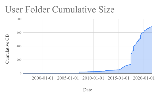
A while back 2TB of storage seemed like plenty. Ooops.
It doesn't help that I'm a digital hoarder. I have everything from email mailboxes from the early 90s to obsolete Android virtual machines that will never run again. I've been forced to do something about it by filling up my backup drive.
My current backup strategy is to send everything to Google Drive. And then send all my pictures to Amazon Photos (free with Prime!). And then backup everything to an external drive (using my VSS tool) every month and stick it in a fire safe because Google and Amazon do not care about my files like I do.
I wrote a little utility to dump some stats to help me accept the problem and then do some tidying. Here's storage over time (imperfect, based on earliest of creation and last write time):
Some of that is driven by ever better cameras and increased willingness to shoot 4K video. Some of it is crazy projects that I forgot to tidy up after, like making a daily timelapse movie from a nest cam.
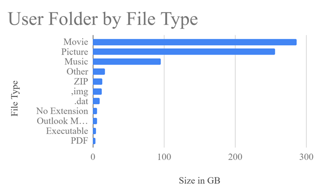
Here's a breakdown by file type:
Mostly media. New resolution, when I take 500 photos of my thumb I should delete all but the very best right after uploading instead of saving them in case I want to make some kind of thumb-animation later.
The most useful thing the utility does is dump out each folder with more than 1GB of files. That found a lot of cruft hiding in unexpected places (bye bye every frame of the 2017 eclipse that I accidentally left in Google Drive instead of my dedicated time lapse disk). I might improve this over time, but all of the above is available now as folder-insights on GitHub.
(Published to the Fediverse as:
Folder Insights #code#backup A tool that shows storage over time, and by file extension, and finds folders with more than 1GB of files. Windows, source on GitHub.)