Bon Tempe Lake
By Robert Ellison. Updated on
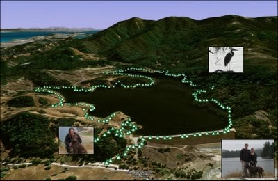
(3.98 miles, total elevation gain 1,306 feet, 1 hour 40 minutes (average 2.39 mph), view in Google Earth)
Hike starts at: 37.958717, -122.6088.
(3.98 miles, total elevation gain 1,306 feet, 1 hour 40 minutes (average 2.39 mph), view in Google Earth)
Hike starts at: 37.958717, -122.6088.
Add Comment
All comments are moderated. Your email address is used to display a Gravatar and optionally for notification of new comments and to sign up for the newsletter.